*
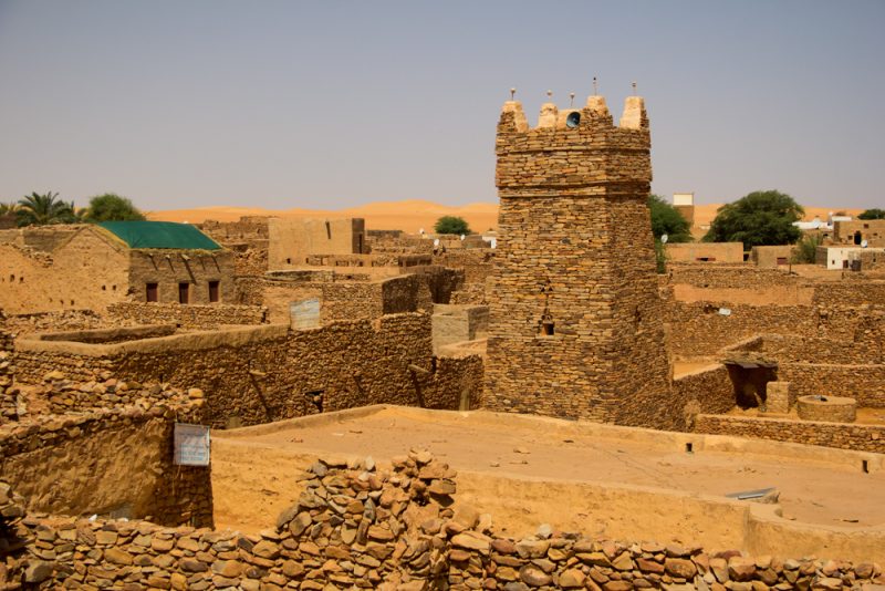
Word die antieke dorpies en stede ingesluk deur die hitte, golwe van sand en woestyn? Chinguetti is in Noord-Mauritanië geleë en dit word ook die sewende heiligste stad in Islam genoem. Dit is volgens hul antieke waardes, die tuiste van sommige van die wêreld se belangrikste Middeleeuse Korantekste. Dit is in 777 nC gestig en was eens ‘n lewendige en lewensbelangrike middelpunt van godsdienstige en wetenskaplike wetenskap. By die samevloeiing van ‘n aantal Trans-Sahara-handelsroetes, het dit teen die 11de eeu ‘n florerende handelsentrum geword. Dit het verander maar wat het daartoe aanleiding gegee?
Chinguetti in Mauritanië

*
Chinguetti in Mauritanië
Chinguetti het op sy hoogtepunt 30 biblioteke gehad wat belangrike manuskripte gehuisves het. Vandag is net 13 van hulle oor en vyf is oop vir die publiek. Hierdie 13 biblioteke hou steeds duisende manuskripte – waarvan sommige uit die 12de eeu dateer – wat onderwerpe van Islam tot sterrekunde en wetenskap dek.
Is dit belangrik vir die res van ons en wat kan die res van ons daaruit leer?
*
PROBLEME VAN VERSENGENDE HITTE EN WOESTYNGEBIEDE
Die vinnig groeiende Sahara-woestyn bedreig ‘n Middeleeuse handelsentrum wat ook belangrik is vir Soenni-Moslems.
Die Sahara woestyn brei suidwaarts uit teen ‘n tempo van 30 myl per jaar – en ‘n deel van die woestyn se onlangs verworwe gebied is ‘n 260-akker stuk grond in noord-sentraal Mauritanië, die tuiste van die dorpie Chinguetti, eens ‘n lewendige handels- en godsdienssentrum . Sand hoop op in die smal paadjies tussen vervalle geboue, in die binnehowe van verlate huise en naby die moskee wat sedert die 13de eeu Sunni-pelgrims gelok het. Na ‘n besoek in 1996 het skrywer en fotograaf Kit Constable Maxwell voorspel dat Chinguetti binne geslagte spoorloos begrawe sou word , ingesluk deur die sand woestyn. Soos soveel woestyndorpe deur die geskiedenis, is dit ‘n slagoffer van tyd en die veranderende gesig van die mensdom se kulturele evolusie,” het hy geskryf.
Die Verenigde Nasies se Opvoedkundige, Wetenskaplike en Kulturele Organisasie (UNESCO) daardie selfde jaar het toevallig die dorp as ‘n Wêrelderfenisgebied aangewys, wat sy ryk verlede en onseker toekoms beklemtoon het. Tog het Chinguetti se lotgevalle nie verbeter nie. ‘n Dekade later het ‘n UNESCO-verslag opgemerk dat globale klimaatsverandering ‘n een-twee-slag lewer: seisoenale kitsvloede, wat erosie veroorsaak, en verhoogde verwoestyning, wat lei tot meer gereelde sandstorms en verdere erosie. Werkers in Chinguetti het die Sisyfiese taak om die sand nat te maak om te verhoed dat dit rondgewaai word.
Vandag se Chinguetti is ‘n skaduwee van die welvarende metropool wat dit eens was. Tussen die 13de en 17de eeue het Soennitiese pelgrims op pad na Mekka jaarliks hier bymekaargekom om handel te dryf.
Woestynkaravane was die bron van Chinguetti se ekonomiese welvaart, met soveel as 30 000 kamele wat op dieselfde tyd daar bymekaargekom het. Die diere, wat by die oase-toevlugsoord verversings gedrink het, het wol, gars, dadels en giers na die suide gedra en met ivoor, volstruisvere, goud en slawe teruggekeer.
Eens die tuiste van 20 000 mense, het Chinguetti nou net ‘n paar duisend inwoners, wat hoofsaaklik op toerisme staatmaak. Geïsoleerd en moeilik bereikbaar (65 myl vanaf Atar, per Land Rover; kamele word nie aanbeveel nie), dit is nietemin die mees besoekte toeristeplek in die land; sy moskee word algemeen beskou as ‘n simbool van Mauritanië. Nie-Moslem-besoekers word verbied om die moskee binne te gaan, maar hulle kan die kosbare Koraniese en wetenskaplike tekste in die ou wyk se biblioteke bekyk en tradisionele nomadiese gasvryheid in eenvoudige omgewing ervaar en bestudeer.
Sulke bewaringspogings sal nie die onvermydelike voorkom nie, aangesien die Sahara voortgaan om suidwaarts te kruip. Verwoestyning is al eeue lank ‘n voortdurende proses in Mauritanië. Neolitiese grotskilderye wat by die Amogjarpas gevind is, tussen Chinguetti en Atar, beeld ‘n welige grasveld uit wat wemel van kameelperde en wildsbokke. Vandag is daardie landskap onvrugbaar. May Cassar, professor in volhoubare erfenis aan die University College London en een van die skrywers van die 2006 UNESCO-verslag oor klimaatsverandering, sê om die probleem van woestynvorming op te los vereis ‘n volgehoue poging deur gevorderde tegnologieë te gebruik.
Is daar hoop hiervoor?
The rapidly expanding Sahara Desert threatens a medieval trading center that also carries importance for Sunni Muslims
The Sahara is expanding southward at a rate of 30 miles per year—and part of the desert’s recently acquired territory is a 260-acre patch of land in north-central Mauritania, home to the village of Chinguetti, once a vibrant trading and religious center. Sand piles up in the narrow paths between decrepit buildings, in the courtyards of abandoned homes and near the mosque that has attracted Sunni pilgrims since the 13th century. After a visit in 1996, writer and photographer Kit Constable Maxwell predicted that Chinguetti would be buried without a trace within generations. “Like so many desert towns through history, it is a casualty of time and the changing face of mankind’s cultural evolution,” he wrote.
Coincidentally, that same year the United Nations Educational, Scientific and Cultural Organization (UNESCO) designated the town a World Heritage Site, which spotlighted its rich past and precarious future. Yet, Chinguetti’s fortunes have not improved. A decade later, a UNESCO report noted that global climate change is delivering a one-two punch: seasonal flash flooding, which causes erosion, and increased desertification, which leads to more frequent sandstorms and further erosion. Workers in Chinguetti have the Sisyphean task of wetting down the sand to prevent it from being blown about.
Today’s Chinguetti is a shadow of the prosperous metropolis it once was. Between the 13th and 17th centuries, Sunni pilgrims en route to Mecca gathered here annually to trade, gossip, and say their prayers in the spare, mostly unadorned mosque, built from unmortared stone. A slender, square-based minaret is capped by five clay ostrich egg finials; four demarcate the cardinal directions and the fifth, in the center, when seen from the West, defines the axis toward Mecca.
Desert caravans were the source of Chinguetti’s economic prosperity, with as many as 30,000 camels gathering there at the same time. The animals, which took refreshment at the oasis retreat, carried wool, barley, dates and millet to the south and returned with ivory, ostrich feathers, gold and slaves.
Once home to 20,000 people, Chinguetti now has only a few thousand residents, who rely mostly on tourism for their livelihood. Isolated and hard to reach (65 miles from Atar, by Land Rover; camels not recommended), it is nonetheless the most visited tourist site in the country; its mosque is widely considered a symbol of Mauritania. Non-Muslim visitors are prohibited from entering the mosque, but they can view the priceless Koranic and scientific texts in the old quarter’s libraries and experience traditional nomadic hospitality in simple surroundings.
Chinguetti is one of the four ksours, or medieval trading centers, overseen by Mauritania’s National Foundation for the Preservation of Ancient Towns (the others are Ouadane, Tichitt and Oualata). The United Nations World Heritage Committee has approved extensive plans for the rehabilitation and restoration of all four ksours and has encouraged Mauritania to submit an international assistance request for the project.
But such preservation efforts won’t forestall the inevitable, as the Sahara continues to creep southward. Desertification has been an ongoing process in Mauritania for centuries. Neolithic cave paintings found at the Amogjar Pass, located between Chinguetti and Atar, depict a lush grassland teeming with giraffes and antelope. Today, that landscape is barren. May Cassar, professor of sustainable heritage at the University College London and one of the authors of the 2006 UNESCO report on climate change, says that solving the problem of desertification requires a sustained effort using advanced technologies.
https://www.afikra.com/daftarjournal/chinguetti
https://www.smithsonianmag.com/travel/endangered-site-chinguetti-mauritania-54168194/
*
Hoe leef mense in so ‘n dorre woestyn, met net ‘n oseaan wat met sand gevul is? Daar is altyd hoop op verbetering.
Die groen en lewe word ingeblaas en ingewerk in die grootste woestyn in Afrika. Waar daar ‘n wil is, is ‘n weg.
https://www.youtube.com/watch?v=fPqVSagqB7I
https://www.youtube.com/watch?v=dL9atXny7gg&t=14s
*
Die Sahara – Antieke biblioteek
https://www.youtube.com/watch?v=LMHfYnS65w0
*
Putte moet steeds onderhou en bewerk word vir die beste resultate. Woestyn gebiede kan verbeter word. Om reënwater op te vang is belangrik.
https://www.ccardesa.org/zai-pits
Myns insiens is en word die klimaatskrisis deur mense en organisasies geskep, juis om mense van hul grond af te kry vir minerale rykdomme. Moenie alle plekke ontbos nie, dis belangrik om skaduryke omgewings te bewaar vir toekomstige en wisselvallige (of beplande) klimaatsveranderinge. Plant inheemse bome aan waar moontlik.
Landbouers moet oral beskerm word.
Boere moet beskerm word en ag slaan op hul eie beveiliging en metodes om voedsel te produseer.
ZAI PUTTE
Kitui County in Kenia is ‘n droë landskap waar kleinboere baie uitdagings in die gesig staar. Lae reënval, grondagteruitgang en lang tydperke van droogte maak dit vir hulle moeilik om oorvloedige oeste te kweek en hul gesinne te onderhou. In die lig van ‘n groeiende (sogenaamde) klimaatkrisis, waar onvoorspelbare reën en droogtes meer algemeen voorkom, word die situasie net erger. Maar daar is hoop. Zai-putte gee kleinboere in Kitui die hoop op ‘n groener, meer veerkragtige toekoms.
‘n Zai-put is ‘n water-oestegniek wat behels dat gate in die grond gegrawe word en dit met organiese materiaal soos kompos, deklaag en mis gevul word. Sodra die gat gevul is, plant boere groentesaad soos ui, kool en spinasie, in die middel en bedek dit met ‘n laag grond of deklaag.
*
Kitui County in Kenya is a dry landscape where smallholder farmers face many challenges. Low rainfall, land degradation and prolonged periods of drought, make it difficult for them to grow bountiful harvests and support their families. And in the face of a growing climate crisis, where unpredictable rains and droughts are more common, the situation is only getting worse. But there’s hope. Zai pits are giving smallholder farmers in Kitui the hope of a greener, more resilient future.
A zai pit is a water harvesting technique that involves digging holes into the ground and filling them with organic matter like compost, mulch and manure. Once the hole is filled, farmers plant vegetable seeds like onion, kale and spinach, in the centre and cover it with a layer of soil or mulch.
https://www.greenpeace.org/africa/en/blogs/7050/using-zai-pits-to-harvest-scanty-rain-water/
*
VERWANTE ARTIKELS EN INLIGTING
Hoggar gebergtes, Sahara Algerië
Sahara – Libya’s Forbidden Deserts
Sahara – Wadi Takarkori region
*
WAT BOERE RAAK
Geen boer – geen voedsel
Food security – Voedselsekerheid
Mynbedryf, landbou, ekonomie, werkskepping, voedsel
Onregte en menseregte skendings teenoor Boere in SA
Boere volksvryheid – Boere republieke
Anglo-Boere oorloë konsentrasiekampe en verskroeide aarde
Oud president Paul Kruger en 20+ Boere republieke
Die Engelse ryk teen die Boere volk
*
Contact Admin:
Admin kan gekontak word by
volksvryheid9@gmail.com
*

[…] Skatte van Afrika […]
LikeLike
[…] Skatte van Afrika […]
LikeLike
[…] Skatte van Afrika*Contact Admin:Admin kan gekontak word byvolksvryheid9@gmail.com* […]
LikeLike