The Wadi Takarkori region where the discovery was made is already being described as an “untapped treasure” with hundreds of sites awaiting excavation. Tafuri and her colleague Savino di Lernia began excavating the archaeological site between 2003 and 2006. Other archaeologists have also uncovered huts, animal bones and pots with traces of the earliest fermented dairy products in Africa.

*
Aquatic fauna from the Takarkori rock shelter reveals the Holocene central Saharan climate and alaeohydrography
Archaeozoological studies on early Holocene sites are rare in Libya: besides the work carried out in Haua Fteah and some other late Quaternary sites excavated in Cyrenaica , and the analysis of surface material collected in the area between the Edeyen of Murzuq and the Kufra basin , faunal data are mainly available from excavations in the Tadrart Acacus massif and the Messak plateau.
Wetlands
If we consider the Tadrart Acacus massif and adjoining regions, we can identify several former wetlands that were active during the AHP, and that are today desiccated. The region can be divided into two major hydrographic basins, divided by a watershed roughly corresponding to the western escarpment of the Tadrart Acacus massif
https://journals.plos.org/plosone/article?id=10.1371/journal.pone.0228588
*
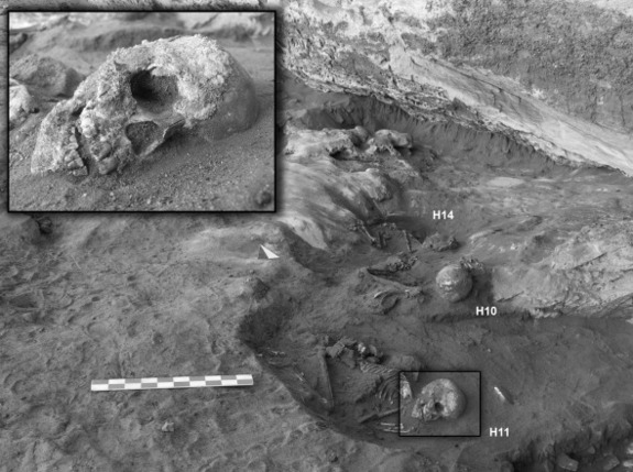
Skeletons dating back to between 8,000 and 4,200 years have been discovered by archaeologists in Libya’s Sahara desert. The team discovered 20 Stone Age skeletons in and around a rock shelter which is believed to have been a local cemetery.
About 15 women and children were found buried in the rock shelter, while 5 men and juveniles were discovered under giant stone heaps outside the shelter. These may have been buried at a later period when the region turned into a desert. It’s assumed that their culture and traditions adapted to the climate change. Studies concluded that the Sahara desert region of Wadi Takarkori used to have a scrubby vegetation with seasonal green patches about 6,000 to 8,000 years ago.
Archaeologist Mary Anne Tafuri of Cambridge University said the site “must have been a place of memory” where generations have been buried. The burial ground is divided between the two sexes which seemingly means that the society was based on gender. Marina Gallinaro, a researcher in African studies at Sapienza University of Rome who is not part of the team, claimed that it could mean that women had a more prominent role in the society before the transformation of the region into a desert.
The new discovery also highlights the need to protect the fragile region, which has been closed to archaeologists since the uprising against Ghadafi began. Wadi Takarkori is very close to the main road to Niger.
https://northafricapost.com/2893-libya-stone-age-skeletons-discovered.html
*
THE TOMBS
The long tradition of collaboration between (historic and prehistoric) archaeology and skeletal biology within the Italian-Libyan Mission in the Acacus and Messak originates more than 50 years ago with the discovery of a mummified child at Uan Muhuggiag (Wadi Teshuinat, Acacus).
http://www.acacus.org/research-1/palaeoanthropology
*
An international team of researchers has discovered the first unequivocal evidence that humans in prehistoric Saharan Africa used cattle for their milk about 7,000 years ago.
By analyzing fatty acids extracted from unglazed pottery excavated from an archaeological site in Libya, the researchers showed that dairy fats were processed in the vessels. This first identification of dairying practices in the African continent, by prehistoric Saharan herders, can be reliably dated to the fifth millennium BC.
Around 10,000 years ago the Sahara Desert was a wetter, greener place. Early hunter-gatherer people in the area lived a semi-sedentary life, utilizing pottery, hunting wild game and collecting wild cereals. Then, around 7,000-5,000 years ago as the region became more arid, the people adopted a more nomadic, pastoral way of life, as the presence of cattle bones in cave deposits and river camps suggests.

http://www.sci-news.com/archaeology/article00408.html
*
A number of sites from this Collection are located in the Libyan Desert, notably the Fezzan region, and include paintings of chariots in a variety of forms dating to the Horse Period, from up to 3,000 years ago. This has stimulated some interesting questions about the use of chariots in what appears to be such a seemingly inappropriate environment for a wheeled vehicle, as well as the nature of representation. Why were chariots used in the desert and why were they represented in such different ways?

>
The chariot has been one of the great empowering innovations of history. It likely originated in Mesopotamia about 3000 BC due to advances in metallurgy during the Bronze Age, and has served as a primary means of transport until quite recently in the historical period across Africa, Eurasia and Europe. Chariots provided rapid and efficient transport, and were ideal for the battlefield as the design provided a raised firing platform for archers . As a result the chariot became the principal war machine from the Egyptians through to the Romans; and the Chinese, who owned an army of 10,000 chariots. Indeed, our use of the word car is a derivative of the Latin word carrus, meaning ‘a chariot of war or of triumph’.

The chariot in the Sahara was probably introduced by the Garamantes, a cultural group thought to be descended from Berbers and Saharan pastoralists. There is little textual information about the Garamantes, documentation comes mainly from Greek and Roman sources.
Herodotus described them as ‘a very great nation’. Recent archaeological research has shown that the Garamantes established about eight major towns as well as numerous other settlements, and were ‘brilliant farmers, resourceful engineers, and enterprising merchants’.
The success of the Garamantes was based on their subterranean water-extraction system, a network of underground tunnels, allowing the Garamantian culture to flourish in an increasingly arid environment, resulting in population expansion, urbanisation, and conquest.
*
Why are chariots depicted in a variety of ways, and what can we say about the nature of representation in relation to chariots? It is clear that chariots are able to be depicted in profile view, yet there are variations that digress from this perspective. In relation to the few examples we have come across so far in the Acacus Mountains in south-western Libya, one observation we might make is that the ways in which chariots have been represented may be indicative of the ways in which they have been observed by the artists representing them; as a rule from above. The rock shelters in the Acacus are often some height above the now dried up wadis, and so the ways in which they conceived of representing the chariot itself , whether as a flying gallop chariot, a chariot drawn by a bovid or as an abstraction, may have become a particular representational convention. The ways in which animals were represented conformed also to a convention, one that had a longer tradition, but chariots were an innovation and may have been represented as they were observed; from higher up in the rockshelters; thus chariots were conceived of as a whole and from an aerial perspective.
https://africanrockart.britishmuseum.org/thematic/chariots-in-the-sahara/
*
It is one of the most inhospitable places on earth. A sun-scorched furnace of rock and sand 700 miles from the coast: the Central Sahara. Summer temperatures can reach 55ºC. Average annual rainfall is less than half an inch. Sometimes it does not rain for years. Across a 250,000 square mile swathe of it – the Fazzan province of south-western Libya – just 79,000 people were recorded in 1964: one every 8km square. Yet in the middle of it, 2,000 years ago, was an urban civilisation with a written language, pyramid tombs, irrigation, agriculture, and armies of chariots and cavalry: the Garamantes.
Until recently, we knew virtually nothing about them. Some ancient writers told strange stories about a mysterious people of the desert. Herodotus, the Greek historian and ethnographer of the 5th century BC, reported that the Garamantes spread humus over salty ground to cultivate it, bred cattle that walked backwards to graze because their horns were too long, and hunted ‘Troglodyte Ethiopians’ in four-horse chariots.
>
Garamantian houses were usually of mudbrick. David Mattingly’s team excavated two long rectangular buildings, each of two or three rooms, both with a hearth, one of them also with a well. They interpreted these as low-status houses or workshops, or a combination of the two. Mudbrick seems to have come in around 500 BC – at the beginning of the ‘Garamantian proto-urban phase’ (500-1 BC) – and has remained central to the building tradition in the Central Sahara ever since. Ashlar stonework came in later – in the ‘Classic Garamantian phase’ (AD 1-400) – but it was then used not just for monumental public buildings, but also for the grander houses, at least at foundation and lower-wall level. Though mudbrick architecture could be elaborate – including fluted columns of moulded and painted mud – stone-footed buildings made a stronger statement about status. Solidly built, multi-roomed, and roughly square in plan, these houses reveal that, at the time of the Roman Empire, Garama was ruled by a prosperous élite.
*
Garama is located in the Wadi Ajal, a sinuous east-west depression some 100 miles long and 2 to 3 miles wide. To the north lies the Dahan Ubari, a great sand sea swelling upwards from the wadi, and to the south, the Massak Sattafat hamada, a barren rock plateau raised up on a towering escarpment. The sand and rock deserts on either side are wholly inimical to life; only the wadi can sustain it. Along its length, field surveys have located some 500 Garamantian sites. Many are cemeteries, but, in addition to Garama, there seem to have been several small towns and about 50 villages and hamlets in the Classic Garamantian period. Four thousand people may have lived in Garama itself, with another 6,000 in suburban satellite villages close by, and perhaps as many as 50,000 in the wadi as a whole. This, however, was not the full extent of Garamantian territory. Garama and the Wadi Ajal were at the centre of a wider Garamantian empire. The Garamantes controlled chains of wadis and oases on the desert caravan routes extending over 100,000 square miles, perhaps doubling the total number of the Garamantian king’s subjects.
Farmers
In places across the desert surface there are white crusts of calcium carbonate and other mineral deposits, representing ancient dried-out lake beds from a time when the Sahara was far wetter than today. Garamantian society developed after the major period of drying out, after the present hyper-arid desert conditions were established about 5,000 years ago. Much of the water was burnt off, but some was sealed as ‘fossil water’ in underground rock formations known as ‘aquifers’. Water-bearing strata ran near the base of the rock plateau to the south of Wadi Ajal – but at a higher level than the wadi depression itself, such that, if tapped, it would flow down into the valley. Here was the secret of Garamantian civilisation.
Garamantian engineers, inspired by irrigation methods developed in Persia and Egypt, dug long underground channels – foggaras – to tap the water trapped in the aquifer at the base of the escarpment and conduct it out into the valley, where it flowed continuously into the oasis and turned it into a Garden of Eden. The channels were generally very narrow – less than 2 feet wide and 5 high – but some were several miles long, and in total some 600 foggaras extended for hundreds of miles underground. The channels were dug out and maintained using a series of regularly-spaced vertical shafts, one every 30 feet or so, 100,000 in total, averaging 30 feet in depth, but sometimes reaching 130.
Greek and Roman writers sometimes imply the Garamantes were like the Berbers of north Africa, sometimes like the Negroes of sub-Saharan Africa. Skeletal evidence supports this: the Garamantes seem to have been a mixture, much as we might expect; similar that is to the present-day population of the Central Sahara. Probably, too, they were a confederation of desert tribes, whether formed willingly or through the dominance of the group centred on Garama.
Some may have migrated to the Fazzan from oases further east, nearer Egypt, bringing some of the techniques of civilisation with them. As well as irrigation, masonry building, and forms of architecture, the Garamantes introduced the horse, the camel and wheeled transport to the Sahara. They also brought writing – short funerary inscriptions in the ancient Libyan language are rendered in a script formed of circles, crosses, squares, arrows and zigzags. The mélange of native, Egyptian and Graeco-Roman elements apparent in temple design and funerary monuments implies some such cultural mixing. But most Classical period Garamantes were probably descendants of the local Neolithic farmers who had arrived in the area around 1000 BC, building a series of small hillfort settlements along the escarpment at the edge of the wadi.
https://www.world-archaeology.com/features/garamantes-libya/


*
The Sahara is the largest hot desert in the world, and the third largest after Antarctica and the Arctic. It spans an enormous area of 3.6million square miles – about the size of China or the USA. Ancient ruins in the Sahara Desert.
Sahara – Libya’s Forbidden Deserts
*
Around 130,000 to 100,000 years ago the Sahara desert was not the sea of sands it is today. Instead, three large rivers created green corridors that linked sub-Saharan Africa to the Mediterranean and could have provided a safe means of passage for migrating ancient humans, according to a new study.
*
A gigantic geological structure in the Sahara Desert of Mauretania, which is seen in this satellite image, is measuring approximately 50 km (32 miles) in diameter. It is known as the Richat Structure and has been a familiar landmark since the earliest space missions. It is one of the most unique rock formations on Earth and it is called the ‘bulls eye’ by space stations. The structure, which is clearly visible from space, is located between the Tiris Zemmour and Adrar (in the northern-most region of Mauritania) and surrounded by thousands of square miles of nearly featureless desert.
Atlantis – the Richat Structure – near Ireland – Western Africa
*
More than one face emerge from the landscape when seen from the air. Located in southeastern Alberta, Canada, near Medicine Hat, this great geological wonder can only be seen from high above the ground. Nevertheless, its humanoid details are stunning when one considers that human hands took no part in shaping this large mass of rock. The profile was formed by the erosion of rainwater on layers of clay-rich soil. Do they speak.

[…] Sahara – Wadi Takarkori region […]
LikeLike
[…] Sahara – Wadi Takarkori region […]
LikeLike
[…] Sahara – Wadi Takarkori region […]
LikeLike
[…] Sahara – Wadi Takarkori region […]
LikeLike
[…] Sahara – Wadi Takarkori region*Contact Admin:Admin kan gekontak word byvolksvryheid9@gmail.com […]
LikeLike
[…] gebergtes, Sahara Algerië Tamanrasset-rivier Sahara Sahara – Libya’s Forbidden Deserts Sahara – Wadi Takarkori region * Contact Admin: Admin kan gekontak word by […]
LikeLike