*
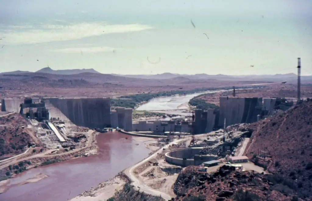
Die konstruksie van die Hendrik Verwoerddam (later na Gariep verander), het sowat 9 jaar geduur. Miljoene vind baat by hierdie projekte en dit word steeds gedoen. Daar het later van tyd heelwat ander projekte hieruit voortgespruit. Water is deel van ons lewens so is voedsel en ander besighede. Konstruksie van die dam het in 1965 begin en die dam is was in 1971 voltooi. Dit was deur die ou regering gedoen, met geld wat uit ons en ons voorouers se sakke gekom het.
*
WATER- EN ELEKTRISITEIT OPWEKKINGSPROJEK
Daar was al heelwat droogtes aangeteken en dis juis so beplan dat hierdie magtige rivier oor provinsies heen, gedeel kan word. Dit het groot geld gekos, maar dis ‘n ope vraag of dit vandag benut word, of selfs onderhou word. Indien dit nie onderhou of benut word nie, is dit tragies dat water uit die skema onwettig weerhou word van burgers van die land. Dis nie asof hierdie kanale nie gebou is nie. Volg dit dieselfde voorbeeld as Eskom of andersom? Daar is baie besproeiing wat gedoen kan word uit hierdie dam en ook die riviere wat uitvloei uit die rivier.
Die ernstige droogte van 1966 en 1967 het die noodsaaklikheid beklemtoon om met werk aan die Skoenmakerskanaal met ‘n kapasiteit van 22 m3/s te begin om die Groot Visrivier so gou moontlik met die Darlingtondam te verbind. In die lig van ‘n verwagte toename in besproeiing onder die Darlingtondam en die vraag na water in die Port Elizabethse metropolitaanse gebied, is besluit om die Wellington Grove-pompstasie te vervang met De Mistkraal Weir stroomop van Wellington Grove en ‘n kort gedeelte van die verbindingskanaal met die begin van die Skoenmakerskanaal.
Daar is hidro-elektrisiteit ingewerk om krag op te wek, wat ons juis broodnodig gehad het op die stadium van ontwikkeling en vooruitgang. Eskom gebruik dit steeds, al is dit kwansuis ou sisteem. Niemand van ons wat dit nagevolg het, het die regering geboikot of probeer afbreek nie, want die dam het ons gehelp om te voltooi met belastinginkomste. Dit was vir almal van ons, nie net vir ‘n sekere volk gebou nie.
Die Oranjerivierwater word van die Groot Visrivier deur ‘n keerwal by Elandsdrift herlei in ‘n akwaduk wat ongeveer 65 km langs steil hange kronkel en deur die Bosberg-ketting tussen Cookhouse en Somerset-Oos sny. Die hoofkenmerk van hierdie akwaduk is die 13,1 km Kookhuistonnel deur die Bosberge, wat in 1978 voltooi is.
Die kanaal vloei in die Klein-Visrivier naby Somerset-Oos via ‘n veelstap-geut, vanwaar die water vir sowat 40 km in die Klein-Visrivier afvloei tot by die De Mistkraal Weir. Die droogtes van die verlede het ‘n kritieke situasie in die Darlingtondam (voorheen Lake Mentz)-streek geskep wat, ondanks die feit dat dit ‘n vrugbare gebied is, ‘n versekerde watervoorsiening benodig.
*
ORANGE RIVER
The Orange River water is diverted from the Great Fish River by a weir at Elandsdrift into an aqueduct which winds approximately 65 km along steep slopes and cuts through the Bosberg chain between Cookhouse and Somerset East. The main feature of this aqueduct is the 13,1 km Cookhouse Tunnel through the Bosberg, which was completed in 1978.
The canal discharges into the Little Fish River near Somerset East via a multi-stepped chute, from where the water flows down the Little Fish River for some 40 km to the De Mistkraal Weir. The droughts of the past have created a critical situation in the Darlington Dam (formerly Lake Mentz) region which, despite being a fertile area, requires an assured water supply.
The serious drought of 1966 and 1967 emphasized the necessity to commence work on the Skoenmakers Canal with a capacity of 22 m3/s to link the Great Fish River to Darlington Dam as soon as possible. In view of an expected increase in irrigation below Darlington Dam and the demand for water in the Port Elizabeth metropolitan area, it was decided to replace the Wellington Grove pumping station with De Mistkraal Weir upstream of Wellington Grove and a short section of connecting canal to the beginning of the Skoenmakers Canal.
With the completion of the De Mistkraal Weir in 1987 the possibility of transferring water to Darlington Dam at the full design capacity of the Skoenmakers Canal was created. This water dilutes the salinated water of Darlington Dam and therefore presents an immediate benefit by improving the water quality for citrus farming in the lower Sundays River valley. A long-term economic benefit of the weir is the development of irrigation potential in the lower Sundays River valley. As a result of the developments, a further 16 500 ha can now be utilized for citrus farming.
The lower Fish River Scheme was initiated in 1985 and completed in 1992. The purpose of this scheme is to provide sufficient water of a suitable quality to irrigation developments along the Great Fish River in the vicinity of Committees Drift. The scheme consists of the Hermanuskraal Weir in the Great Fish River with a tunnel to discharge flood water and water released from the Orange River into an off-channel storage dam, the Glen Melville Dam in the Ecca River. The distribution system consists of a canal and pipelines to the irrigation areas on both sides of the river. The scheme will enable further irrigation expansion and will ensure that water of an acceptable quality is supplied.
The scheme also makes provision for Grahamstown’s increasing requirements. When the scheme was started, Grahamstown was already experiencing problems in meeting its growing demand for water and the Fish River was the obvious source to serve as a supplement. The scheme ensures that a stable supply of good quality water is available, which can be linked to the municipal water supply network. The scheme also benefits rural communities in the Great Fish River catchment (including portions of the former Ciskei) by improving the quality and availability of water.
http://www.dwaf.gov.za/orange/Mid_Orange/fish-sun.htm
http://www.dwa.gov.za/Projects/Orange%20Recon/sa.aspx
*
Bedrock underground at the base of the Hendrik Verwoerd Wall (Gariep) Free State Province, South Africa
THE ORANGE RIVER PROJECT (ORP)
The Hendrik Verwoerd dam (later Gariep) was the first dam where the construction was put out to tender by the DWAF who had previously planned, designed and constructed all major water works commissioned in South Africa. The tender was awarded to Union Corporation/Dumez Borie Dams in 1966 and it was commissioned in 1971.
Water from the dam was transferred to the Fish and Sundays basins via the Orange/Fish Tunnel which was until recently the longest continuous water transfer tunnel in the world with a length of more than 82km. The ORP was undertaken to evaluate the water requirements and available resources in the Orange River as well as the impact of the Lesotho Highlands Water Project on these resources.
In this regard, a full system analysis of the Orange River was started in 1987 and completed in 1993. This initial study was called the Orange River System Analysis was subsequently updated by the Orange River Replanning Study which was started in 1994 and completed in 1998. Further studies are continually being carried out to investigate specific development options in a continuous effort to plan the efficient use of Orange River water. The quantity of water available for development in the orange River is constantly being assessed and other aspects such as the influences of further developments on the water quality and environment are also being analysed.
*
*
*
*
*
HISTORY OF THE ORANGE RIVER PROJECT
The Orange River and its major tributary, the Vaal River, convey nearly 23 % of the total surface water of South Africa. Considering the generally dry climatic conditions characterising the sub-continent, it is essential for this fresh water resource to be utilized to the greatest benefit of the country and its people, including those of Namibia.
The pioneer in the development of the water resources of the Orange River was Dr AD Lewis, one of the first administrative heads of the then Department of Irrigation (now the Department of Water Affairs and Forestry). As a result of recurring droughts in the Eastern Cape, Lewis, as early as 1928, broached the idea of building a tunnel from a point near Bethulie underneath the Suurberg Plateau to convey Orange River water via the Teebusspruit and the Brak River to eventually reach the Great Fish River valley.
This concept was followed up in 1944 when field surveys and drilling were initiated. This resulted in a report to the Government in 1948 which proposed a project comprising amongst others, a diversion dam on the Orange River as well as a diversion canal and tunnel underneath the divide to the Great Fish River valley, with a branch canal to the Sundays River valley. The first White Paper on the project was tabled in Parliament in 1951 and the actual development was started soon thereafter.
The developments associated with the Orange River are currently spread over six of the nine provinces of the country, namely Northern Cape, North West, Gauteng, Orange Free State and Eastern Transvaal. Orange River water currently supplies water to consumers in an area from Bloemfontein in the East to Port Elizabeth in the South and Alexander Bay at the river mouth in the West. The first water from the Lesotho Highlands Water Project was transferred to the Vaal River basin in October 1997 for testing purposes and the first main supplies are scheduled for 1998.
http://www.dwaf.gov.za/orange/Mid_Orange/overview.htm
*
As depicted on the inserted map of the study area, the study will focus on the water resources of the Upper and Lower Orange River Water Management Areas (WMAs), while also considering all the tributary rivers and transfers affecting the water balance of the system. This core area forms part of the Orange-Senqu River Basin, which straddles four International Basin States with the Senqu River originating in the highlands of Lesotho, Botswana in the north eastern part of the Basin, the Fish River in Namibia and the largest area situated in South Africa.
Since 1994, a significant driver of change in the water balance of the Orange River System was brought about by the storing of water in Katse Dam as the first component of the multi-phase Lesotho Highlands Water Project (LHWP). Currently Phase 1 of the LHWP (consisting of Katse, and Mohale dams, Mosoku Weir and associated conveyance tunnels) transfers 780 million cubic metres per annum via the Liebenbergsvlei River into the Vaal Dam to augment the continuously growing water needs of the Gauteng Province.
*
EXCELLENT WORK
This 82.5km tunnel carries water from Oviston at the Gariep Dam to the Fish River valley with the outlet at Teebus about 23km south west of Steynsburg . It is the fifth longest tunnel in the world (Wikipedia) with a diameter of 5.35m and a fall of 77m. It is part of the Orange River Project which was the brainchild of Dr AD Lewis who, as Secretary of Water Affairs, launched the idea in 1928.

*
*
Kakamas developed as a town in the late 1800’s and during this period of war and world depression the bitterly poor people from the surrounding areas came to the church in Kakamas for help. They were offered the option of trading their labour for food.
Canals had already been built in the nearby town of Upington and a similar project was mooted for Kakamas. At a town called Neusberg, about 10km from Kakamas, it was found that the river’s course was such that, if a canal were built, the water would flow automatically, doing away with the need for pumps. Work began on the furrows. Men, women and children dug relentlessly using picks, shovels and their hands. It was said that the earth where they worked would turn into mud from their sweat.
The people would often work at night to escape the intense heat of the day. Two canals or furrows, called the South and the North Canals, were eventually completed. During construction of the North Canal, however, it became obvious that two tunnels would have to be built to maintain a gradient that facilitated automatic water flow. Japie Lütz, from Upington, did the calculations and laid down the necessary measurements. The two tunnels were eventually completed. Amazingly they were both excavated from either side and met precisely. This impressive feat was achieved without the use of modern instruments. These hand-dug tunnels, one of them 160m long, are still in use and have been declared national monuments.
*
*
*
Daar is ander dinge wat voortgespruit het uit die bou van die Hendrik Verwoerd dam.
The ‘Gariep River’ Tunnels Kakamas Northern Cape
Japie Lutz – Engineer from Germany
Those tunnels started already in 1898 and completed in 1911.
Two tunnels were mentioned – 172 and 92 metres.
Look at the work employment as well.
https://www.youtube.com/watch?v=WIOLo0iodcA
*
LOOK AT THIS AS WELL:
VIDEO’S
Die HENDRIK VERWOERD DAM
SYND 5-3-72 OFFICIAL OPENING OF ORANGE RIVER DAM IN SOUTH AFRICA
(4 Mar 1972)
The official opening of the Hendrik Verwoerd Dam on the Orange River by South African President Jacobus Fouche.
Dit is ‘n baie groot dam met baie voordele vir die hele land se inwoners. ‘n Toerisme aantreklikheid.
The Hendrik Verwoerd’s beauty draws visitors all over the world
Also call the Gariep.
It covers 370 square kilometres, holds almost uncountable amounts of water, provides irrigation, electricity and water for drinking and sanitation and draws tourists from all over the country and beyond. The Gariep Dam is many things to many people and remains arguably the most impressive body of water in the country.
*
9 Jaar en hier staan die dam, voed baie siele en veral Boere vir voedselproduksie.
Die Hendrik Verwoerddam
Konstruksie het in 1965 begin en die dam is was in 1971 voltooi.
Amptelike opening was 3 Maart 1972 deur Staatspresident.
https://www.youtube.com/watch?v=zSiAw0bcCBs
*
RELATED
Lesotho Highlands Water Project
Water and Pollution Rooiwal Waste Water Treatment Plant
Water, kanale, hidrokrag en rioolaanlegte
*
Contact Admin:
Admin kan gekontak word by
volksvryheid9@gmail.com

[…] Hendrik Verwoerddam […]
LikeLike
[…] Hendrik Verwoerddam […]
LikeLike
[…] Hendrik Verwoerddam […]
LikeLike
[…] Hendrik VerwoerddamAnder […]
LikeLike
[…] Hendrik Verwoerddam […]
LikeLike
[…] Hendrik Verwoerddam […]
LikeLike
[…] Hendrik Verwoerddam […]
LikeLike
[…] Hendrik Verwoerddam […]
LikeLike
[…] Hendrik Verwoerddam […]
LikeLike
[…] Hendrik Verwoerddam […]
LikeLike
[…] Hendrik Verwoerddam […]
LikeLike
[…] Hendrik Verwoerddam […]
LikeLike
[…] Hendrik Verwoerddam […]
LikeLike