*
P. Robinson en ander skrywers het heelwat interessanthede oor die minerale rykdom in die Himalajas genoem. Die bekende Himalajas waar menige dromer kan gaan klim tot bo-op die toppe van ‘n paar gletsers is ‘n droom vir menige van ons wat dit van ver af bewonder. Dit is soos daar in Switzerland of Frankryk en al die ander gletserlande, wat spog met wat hulle kan vertoon. Dit laat gedagtes vir ‘n oomblik stilstaan.
Daar is mineraal ontginning van seldsame aardelemente (REE), aan die gang is. Die hele bergreeks word versteur met plofstowwe. Dit sluit aan by ander gevaarlike dinge wat gebeur, die oorstromende riviere, die wegspoel van huise en gemeenskappe, burgers wat eenvoudig verdwyn, die tonnelstelsels, die hidro-elektriese projekte, pad en spoorverbindings, al daardie tonnels wat oopgeskiet is, wat hierdie gebergtes moes geskud het tot diep diep in hulle fondamente.
Waar is al die damme en tonnels gebou?
Hierdie gebergtes wat oor verskillende lande strek, is besonders, amper soos ons eie “Tafelberg” in Kaapstad met haar wit kleed op wat inskakel met die hele Skiereiland. Tafelberg is prentjiemooi en sal altyd ‘n spesiale plek in SA bly, ‘n baken om te weet dit is ‘n spesiale kleed en berg. Met ander navorsing, dui ook aan wat hierdie spoor, pad en selfs tonnels en damme aan hierdie hele streek doen. DIT opsigself kan nie gesond wees as alles versteur word nie. Is dit nie genoeg dat daar aardbewings is nie?
Daardie gebreekte formasies van syagtige sand gemeng met puin en rotse uit die Himalajas lyk soos dryfsand wat mense, diere en selfs rotse en bome insluk. Moeilik om reddingswerke te doen en die meesters weet dit, want dit gaan al jare so. So baie mense en diere is al dood, VERMOOR en onder die puin begrawe. Owerhede is by meer as een geleentheid gewaarsku teen al hierdie projekte.
Duisende word steeds vermis met die Nepal en selfs Tibet rampe. Selfs China se eie land loop deur asook die lande onder Tibet en Nepal. Nie almal weet waar hul geliefdes op hierdie dag was nie, of weet hulle? Het hierdie syagtige drillende sand en puin massas van ou mynterreine gekom, of dalk van paaie, spoorweë of selfs eerder die afval uit damme wat ook weggespoel het, verdrink in hul eie massa slik?
Die burgerlikes en rampbeamptes of toeriste, loop versigtig op hierdie sand en dis selfs moeilik vir lugverkeer soos helikopters. Daar is geen woorde of boodskappe op daardie rotse of sandmengsels opgeteken, waar dit vandaan gekom het nie. Tonnels wat ingesluk en ingeslik is, se openinge was onherkenbaar toegemaak.
Dit is ‘n siek storie en Himalaja gebergtes is nie die enigste nie. Die smag na geld, rykdom en minerale, nes in Suid-Afrika en Afrika. Hierdie mengsels, is mensgemaak en is gemeng met iets wat hierdie berge erg omgekrap het. Uit die boeg soos ‘n berg wat vuur spoeg. Klink amper soos drake wat probeer om te oorleef. Heelwat berge bestaan uit oergediertes, drake en reuse.
Net soos wat plofstowwe of iets anders dergeliks, dieper onderaardse skades kon aanrig is berge van onder af so beskadig en menslik onmoontlik om te herstel. Dit kan nooit ooit weer opgebou word nie en sal alles meegee. Dit is iets wat geen bewoner in hierdie sensitiewe areas hul vyande toewens nie, tog word dit teen hulle gebruik in vallende rotse, gemeng met donker massa slikwaters, ‘n massa Tsuname wat binne minute alles verorber het.
Het bewoners van die Himalayas ooit toestemming gegee vir enige plofstowwe vir pad, spoor en damme om elektrisiteit op te wek nie?
Of is hierdie dambouery net ‘n front om eerder op die minerale ontginning te fokus vir wapens …. Hierdie is reeds ‘n area wat onstabiel is met al die aarbewings en verskuiwings. Waarom is hier nooit enige impakstudies gedoen in hierdie streek van die Himalayas nie.
Mens sou dink die ‘wetenskaplikes’ is dan so slim dat hulle sou aangedring het impakstudies en wat die nagevolge is van veral plofstowwe. Hierdie berge raak nie net een land en een volk nie, maar ‘n hele paar. Wie reik al die permitte uit waar daar hier in die Himalayas minerale uitgehaal en selfs uitgevoer word, of hidro-elektriese damme en tonnels met pad en spoor oopgeskiet word? Damme gaan tog nie vir altyd hou met al die gletsers om hulle nie. Dis tog logies en as berge versteur word met pad, spoor en veral plofstowwe, dan sal daar nagevolge wees. Die leiers wat die voordeel uit hierdie prosesse trek, is nie die arm gemeenskappe wie se huise verspoel word of selfs vermoor word nie. Op die oog af lyk dinge nogal opsetlik vir die inwin van meer mag en geld.
Dit laat koue rillings maar eendag sal hierdie berge nog uitroep en alle waarheid ontbloot.
Tonnels, pad en spoor kan nie gebeur sonder dat daar nie plofstowwe gebruik is om al hierdie damme te bou nie. Waarnatoe gaan al die tonnels en damme se binnekante wat uitgeskiet of gemyn word? Hoeveel plofstowwe is die afgelope 30 jaar hier gebruik om die berg nog meer onstabiel te maak en al die bewoners so te laat uitwis, want dit is waarnatoe dit gaan. Uitwissing. Daar is nie net een land hier in die streek nie.
Terug in Augustus 2026 tydens die vloed in NEPAL het uitgekring na ander lande.
Die Nepal vloed van 26 Augustus 2026 het geen waarskuwings gehad nie, dit was te laat, sommige het betyds weggevlug, ander was nie so gelukkig nie. Simpatie aan hulle wat oorlede is en duisende ander wat steeds vermis word.
*
Koue en oorlewing in Nepal Himalaya.
Every spring, in a remote part of Nepal, tens of thousands of villagers leave their dwellings for a dangerous trek to the Himalayas, in order to collect Yarsagumbu, a caterpillar fungus. This peculiar hybrid between plant and insect is being sold in China up to $60 000 per kilo (or 2.2 lbs), because of its medical wonders worth more than its weight in gold.
https://www.youtube.com/watch?v=Vff6qWgD4NM
*
P. Robinson and others write about the Himalayas—those famous Himalayas where many a dreamer might go to climb to the very summits of glaciers. At that point, my thoughts paused. I have read about the extraction of rare earth elements (REE), the overflowing rivers and tunnel systems, the hydroelectric projects, the road and rail connections – all those tunnels blasted open, which must have shaken these mountains to their very foundations. Those fractured formations of silky sand, mixed with debris and rock from the Himalayas, resemble quicksand that swallows everything whole.
So many people and animals have died, buried beneath the rubble. Not only Nepal, but it is ongoing for years in this areas. Thousands of peoples remain missing and houses are just gone for ever. Not everyone knows where their loved ones were on that day – or do they? Did these masses of silky, quivering sand and debris originate from old mining sites, or perhaps from roads, railways, or even all those tunnels and dams?
There are no words or messages inscribed on those rocks or sand mixtures to indicate their origin. Tunnels, swallowed up and engulfed, have mingled with something that severely disrupted these mountains – much like explosives, or something similar, might inflict deep subterranean damage. It is a fate no resident of these sensitive areas would wish upon their enemies, yet it is turned against them in the form of falling rocks mixed with dark masses of silt-laden waters.
Did the inhabitants of the Himalayas, all those countries, ever grant permission for the use of explosives for roads, railways, tunnels and dams to generate power? It is an area that is already unstable due to all the earthquakes and tectonic shifts. Why have no impact studies ever been conducted in this region of the Himalayas? These mountains affect not just one country and one people, but several. Who issues all the permits for the extraction – and even export – of minerals from the Himalayas?
*
RARE EARTH ELEMENTS
2017 quote
The first discovery identified in the field is the widespread Be-mineralization contained in most of leucogranitic plutons. The authors wrote, “Aquamarine, a variety of beryl, major precious mineral resource in Nepal, has been widely explored, exploited and traded for a long time, and there may also be Be-mineralization potential on the Chinese side of the Himalayas.”
Based on the analytical results, the researchers revealed the distribution of the mineralization as: “Rare-metal mineralization was observed in both the Tethyan and Higher Himalayan belts. No clear differences between the two belts were identified. However differences are clear when comparing the eastern and western parts of the belts. The eastern plutons are characterized by Nb, Ta, Sn, and Be mineralization and Sn mineralization is notably absent in western plutons. These results suggest that rare-metal mineralization in the Himalayan leucogranites is regionally variable, but does not appear to be controlled by tectonic characteristics of granite emplacement and the pluton size.”
*
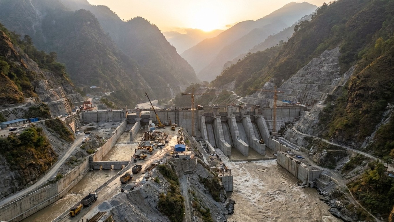
Two thousand meters of drop over fifty kilometers. That is the blunt geography that explains everything. The Yarlung Tsangpo, Tibet’s sacred river, makes a spectacular bend around Namcha Barwa before plunging toward the Indian plains, a natural setup that Chinese engineers have eyed since the 1960’s. In December 2024, the Chinese government approved the project, officially launched on July 19, 2025. The Medog Dam is now under construction. And its dimensions are almost inconceivable.
Key takeaways
- A capacity of 60 GW: roughly triple the Three Gorges Dam and the equivalent of France’s entire nuclear fleet
- Four 20-km tunnels will divert the sacred river of Tibet entirely beneath an unstable mountain
- A hydraulic lever affecting India and Bangladesh: 625 million people depend on this river
Overview
- A concrete giant beneath the sacred mountain
- The price of ambition
- A geopolitically sensitive valve 30 km from the Indian border
- China’s energy transition against a backdrop of tensions
The technical trick that makes this possible lies in the site’s peculiar geography. The river climbs 2,000 meters in elevation over a short 50-kilometer stretch. Four 20-kilometer diversion tunnels would be bored through Namcha Barwa to reroute the Yarlung Tsangpo. The water diverted into these tunnels would drive hydro turbines connected to generators before returning to the river’s course. This is not a conventional dam in the classic sense. The project does not require a water-retention dam. This technique creates a steeper gradient for the water, increasing its force and energy potential. Building multiple underground power stations in series allows the same water to be used multiple times, maximizing electricity production.
The site lies in a very deep canyon, in a zone of high seismic activity, unstable and prone to landslides. Chinese experts warn that a large earthquake could threaten the stability of the construction. Not to mention climate change, which is proceeding faster in Tibet than elsewhere, causing rapid glacier melt and multiplying rockfall risks. In 2022, engineers at the Sichuan provincial geological bureau specifically highlighted landslides and mud and rock flows induced by earthquakes as significant threats to the project’s stability.
The canyon itself has been a protected area since 1988. The Yarlung Tsangpo Canyon is the longest and deepest in the world, carved by the river as it traverses the eastern Himalayas in Tibet. With a depth of 6,009 meters at its lowest point and stretching over more than 500 kilometers, it even surpasses the Grand Canyon in the United States. Drilling four 20-kilometer tubes through one of the planet’s most unstable mountains is the concrete obstacle that Power China’s teams must overcome.
The Yarlung Tsangpo becomes the Brahmaputra in India and then flows into the Jamuna in Bangladesh. That name change encapsulates the tension at the heart of the matter. The Brahmaputra and its tributaries account for more than 30% of India’s water resources, and 94% of those of Bangladesh. 625 million people live in its basin, of whom 80% are farmers who rely heavily on water for their crops. 625 million. That is the combined population of the European Union, the United States, and Mexico.
The fear is that China could use this dam as a valve to curb the river’s flow, or conversely to suddenly increase its discharge, which would be particularly damaging during floods and the monsoon, experts warn. “It’s a time bomb,” warned Pema Khandu, the chief minister of Arunachal Pradesh, through which the Brahmaputra runs. New Delhi is not standing idly by: India plans counter-projects, including a hydroelectric project in the Siang upper district of Arunachal Pradesh, intended to supply 11 gigawatts.
China controls the sources of ten of Asia’s major rivers: the Mekong, the Irrawaddy, the Salween, the Indus, the Ganges, the Brahmaputra, among others. It is, in effect, the water tower of Asia. And it has consistently refused to sign binding treaties on water sharing with downstream neighbors. The Medog project fits into this logic of hydraulic power: producing clean energy to decarbonize an economy still 60% dependent on coal, while solidifying a lever of pressure on two neighboring countries with which relations remain tense.
On the Tibetan side, the human dimension is equally heavy. The project has faced resistance from various quarters, including environmental groups, downstream countries, and Tibetan rights advocates. Similar hydroelectric developments in Tibet have already sparked protests, notably recent demonstrations against the Kamtok dam project on the Yangtze, which led to over 1,000 arrests.
The construction, planned for ten years, will nonetheless permanently transform this corner of the Himalayas. China plans to sell part of the produced electricity to neighboring countries, a way of presenting regional cooperation that remains essentially a unilateral demonstration of power. The idea of diverting an entire river under a mountain at an altitude of 1,500 meters, in a seismic zone, just 30 kilometers from a disputed border, speaks volumes about the appetite for infrastructure in a China that now builds where others would hesitate to even send a reconnaissance team.
*
As of this recording, more than thirteen hundred people are confirmed dead, over five thousand more are still missing, and those numbers climb every day. And they did not die because the water was too fast to outrun. There was a drone in the air that morning, on a Chinese radar station across the border, pointed straight at the peak that failed. Nobody was warned.
At thirty seven minutes past eight, on 26 of August, 2026, it caught a white ribbon peeling off the north face. Less than eight minutes later, a six-story customs building on the border was gone. Whatever hit it kept going for sixty two miles, taking forty one bridges, twenty six miles of highway, a huge share of Nepal’s power grid, and burying the villages below under five feet of gray silt.
The viral drone footage of the collapse was filmed by a Chinese tourist and travel photographer using the social media handle Hei Mu – not the Chinese radar station itself. Hei Mu was at a scenic spot on the Chinese side of the border (near a mountaintop radar station in Tibet) doing a routine aerial drone shoot of the mountain scenery. He did not realize he had captured the collapse—which occurred miles away on the north face of Mount Langtang Lirung in Nepal—until reviewing the footage later. It was a failure of the design of the alarm system itself
https://www.youtube.com/watch?v=ds4qCmw8pas
*
Every spring, in a remote part of Nepal, tens of thousands of villagers leave their dwellings for a dangerous trek to the Himalayas, in order to collect Yarsagumbu, a caterpillar fungus. This peculiar hybrid between plant and insect is being sold in China up to $60 000 per kilo (or 2.2 lbs), because of its medical wonders worth more than its weight in gold.
It is a fact – Mining disrupts natural aquifers. Heavy metal runoff pollutes local river streams, dams and oceans.
Land Degradation & Landslides: Stripping the topsoil and blasting unstable mountain slopes drastically accelerates severe landslides and slope failures.
Black carbon and dust generated from mining operations deposit onto glaciers, accelerating melting in a region already facing a climate tipping point.
The Himalayas contain extensive reserves of Rare Earth Elements (REEs) and other critical rare metals.
Found in the Himalayas
Minerals Found: Includes light-coloured granite formations containing lithium, beryllium, niobium, tantalum, and tin.

*
DIT IS DUIDELIK – OOK HIER IN DIE OOSTE WERK FEDERALISME SISTEME NIE UIT NIE, OOK NIE IN DIE EU LANDE NIE
Volkereg, Konfederasies, Federasies
Nepal – George Soros & Open Society Foundations
Dolma from Tibet
(Tibet is outonomiese staat, val onder China)
*
Dan kla swart en gekleurdes hulle het nie grond nie, hulle lieg openlik – CPA en Trustgebiede behoort aan hulle.
Grond in SA vir landbou en minerale
Minerale in SA Boere republieke, reservate en kroongebiede
Besoedeling in ou Boere republieke
*
Contact Admin:
Admin kan gekontak word by
volksvryheid9@gmail.com
*


