*
Niemand sal regtig weet of die bekende Atlantis, ‘n eens goed en vooruitstrewende ontwikkelde beskawing, onder die golwe gesink het soos wat vermoed word nie. Daar word ook moontlik geredeneer dat Atlantis eerder ‘n weelderige en groen eiland êrens in of naby die Atlantiese oseaan moes gewees het. Laat die verbeelding gly oor die eens groener weivelde van die Sahara en skep ‘n idilliese eiland waar ‘n goed ontwikkelde volk gebly en gewerk het.
*
Die huidige regerings van die dag weet dalk wat met Atlantis gebeur het of weet niks nie. Dat dit maar alles net ‘n raai-raai en bespiegelinge oor dit wat eens ver ontwikkeld en tegnologies gevorderd was.
Wetenskaplike of geografiese geskiedenis, bespiegelinge of teorieë hieroor sal altyd interessant wees en kan aanleiding gee dat jonk en oud wat netso entoesiasties daaroor is om meer te leer en wysheid te bekom. Vir ‘n feit is dit ook so tekens daarop dui dat hierdie gebied, die Sahara eens groen areas moes gewees het.
Die Paradys of Tuin van Eden, waarna die Woord van praat is ook in die streek geleë en was beslis nie in ‘n dorre warm gebied nie, maar groen. Sal die Tuin van Eden dalk vir almal as ‘n welsprekende voorbeeld uitstaan of nie?
*
Wat was Atlantis?
Atlantis is ‘n storie of werklikheid so oud soos die tyd self, maar die oorsprong word nie gereeld bespreek soos dit behoort te wees nie. Alhoewel dit sensasioneel gemaak is om hierdie verlore gesinkte eiland te wees deur rolprente en fiksiewerke, was die eerste Westerse vermelding van hierdie beskawing van die bekende Griekse filosoof, Plato. In sy onvoltooide boek, Timaeus, het die filosoof probeer om die wêreld om hom te beskryf en hoe dit ontstaan het. Oral het dit aandag getrek oor wat Atlantis was en in die aarde weggesink het.
Die boek waarna verwys word, is geskryf in 360 vC, beskryf die reise van die wyse man Solon na Egipte waar hy ‘n priesteres ontmoet het. Die priesteres het verwys na ‘n groot beskawing waarheen haar mense gevlug het na ‘n groot ramp. Hulle hoofstad was welig met struike en georganiseer deur drie sirkels grond wat deur twee sirkels water omring is (Plato, 1925). In die noorde lê ‘n groot reeks berge en ‘n suidelike vloeiende rivier wat deur, of net bokant die stad geloop het. Die priesteres het egter beskryf dat die stad 9 000 jaar tevore deur die see ingesluk is. Daar is tekens van verweer uit die lug te sien oor massas wat eens hieroor gestroom het wat die verbeelding aangryp.
Die blote ouderdom van ‘n skrywe maak die hekke oop vir vertaalfoute en misverstande. Spesifiek, twee aanhalings (verwys as Bewysstuk A en Bewysstuk B) wat wys presies hoe dit kan gebeur (Plato, 1925).
Fisiese ooreenkoms
In die land van Mauritanië, geleë in die westelike streek van die Sahara, het ‘n onheilspellende struktuur die aandag van historici, argeoloë en selfs ruimtevaarders getrek. Hierdie webwerf staan bekend as die Richat-struktuur, meer algemeen bekend as The Eye of the Sahara. NASA-satelliete het die krateragtige gebied gekarteer om 25 myl in deursnee te wees, ‘n soortgelyke grootte as die metropolitaanse gebied van Parys (Meado, 2011). Die ringe van die struktuur is vreeslik soortgelyk aan die beskryfde struktuur van die hoofstad van Atlantis, volgens die 3/2-ringverhouding wat ook duidelik sigbaar is. As gevolg hiervan word teoretiseer dat die Richat-struktuur is wat oorbly van die verlore beskawing van Atlantis. Dus moes alles weggewas het na die oseaan toe en ook toegespoel onder slik, modder en geweldadige waters.
Geologiese Geskiedenis
Interessant genoeg was die Sahara nie altyd ‘n woestyn nie en is daar heelwat bewyse hiervoor. Alhoewel die mensdom dit in die Koran bespiegel het ver voordat klimaatnavorsers ‘wetenskap’ gebruik het om dit te bewys, het die Smithsonian geskat dat dit ‘n redelik tropiese streek was voor 11 000 jaar gelede (Boissoneault, 2017).
Topografiese en gravitasiestudies wat in die Sahara uitgevoer is, het ‘n baie groot netwerk van riviere en mere ontbloot, verlore weens klimaatsverandering. Dis nou wat deur die ‘geleerdes’ bekend gemaak is. Die kans vir enige iets anders, soos oorlog in daardie jare word nie genoem nie, wat ook ‘n sterk moontlikheid is. Hierdie stad was gesofistikeerd, maar waarskynlik het hulle ook vyande gehad op ander kontinente.
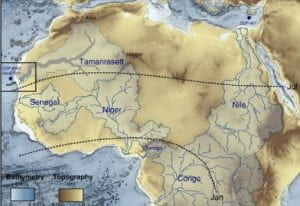
Die riviere Senegal en Niger het byvoorbeeld uitgestrekte rivierbekkens gehad wat staaf aan die idee van ‘n groen Sahara (Klokocnik, 2017). Dis interessantste om te meld dat navorsers in hul data bewyse gevind het van ‘n rivier(e) veel groter, genaamd die Tamanrasset. Net soos die Nyl, sou die grootte van hierdie rivier maklik ‘n gemeenskap onderhou wat in staat is tot landbou, vervoer en handel. Natuurlik sou daar ook mere gewees het in sulke groot riviere. Daar word genoem dat hierdie rivier by die Atlasberge begin, suidwaarts na die Richat-struktuur vloei voordat dit wes draai en in die Atlantiese Oseaan neerslaan . Alhoewel daar geen bewyse van hierdie rivier op die oppervlak van die woestyn is nie, sal die ligging wat in Timaeus genoem word met betrekking tot die hoofstad in lyn wees met inagneming van die verlore rivier. Dat daar water onder is, is ook bewyse gevind.
Dit is moontlik dat sulke riviere meer reën ontvang het, met meergebiede, wat dit so groot gemaak het en maklik oorstroom kan word in die middel van Afrika, Die realiteit is dat die wêreld om ons redelik onvoorspelbaar is. Dis ‘n feit, nie alle gebeure kan toegeskryf word aan globale aardverwarming nie.
Die Nasionale Wetenskapstigting beskryf byvoorbeeld dat daar tussen 50-100 miljoen jaar gelede ‘n waterweg was wat suid van die Middellandse See, deur die Sahara, en met die Atlantiese Oseaan verbind het (NSF, 2019). Bekend as die Trans-Sahara seeweg. Dit is belangrik om daarop te let dat alhoewel hierdie gebeurtenis(se) voortgaan met die ondergang van Atlantis, ‘n massiewe hoeveelheid water sekerlik in staat is om Noord-Afrika te deurkruis. En dat daar iets was wat die water laat oorstroom het. Weermanipulasie word wyd beoefen en dan word die resultate toegeskryf aan ‘aardverwarming’. Destyds met hierdie tipe van gesofistikeerde stede, was hulle ver voor met alle toerusting en ontwikkelings. Atlantis was nie net ‘n spookdorp nie maar waarskynlik een van die bestes van die beste om handel te dryf?
*
ATLANTIS – THE “GHOST CITY”
Everybody knows the name Atlantis — the story of a civilization lost to time—sunken beneath the waves. Personally, the first thought that comes to mind when thinking of Atlantis would be an island somewhere in the Atlantic, probably now home to a couple of fish. This concept of Atlantis seems so far-fetched that it’s easy to write off as just a story. However, what if I told you our government already knows the whereabouts of Atlantis? What if it’s not as lost as we think? Well, recent scientific discoveries continue to deepen our understanding of geographic history which, in turn, helps construct an argument for the reality of Atlantis.
What was Atlantis? and who live there?
Atlantis is a story as old as time itself, however, the origins are not often discussed. Though sensationalized to be this lost sunken island by cinema and works of fiction, the first Western mention of this civilization was from the renowned Greek philosopher, Plato. In his unfinished book, Timaeus, the philosopher attempted to describe the world around him and how it came to be. Since I am not fluent in ancient Greek, I will reference a translation by W.R.M. Lamb transcribed in 1925 for the account.
Written in 360 BC, the book details the travels of the wise man Solon to Egypt where he met a priestess. The priestess referenced a great civilization where her people fled after a great cataclysm. Their capital was lush with shrubbery and organized by three circles of land that surrounded two circles of water (Plato, 1925). To the north lay a great range of mountains and a southern-flowing river that ran through, or just above the city. However, the priestess described that 9,000 years prior, the city was swallowed by the sea.
Now, the sheer age of this writing opens the gates to translation errors and misunderstanding. Specifically, two quotes (referenced as Exhibit A and Exhibit B) show just how this could happen (Plato, 1925).
Exhibit A
On this [island] of Atlantis there existed a confederation of kings …, which held sway over all the [island], and over many other islands also and parts of the continent; and, moreover, [25b] of the lands here within the Straits they ruled over Libya as far as Egypt, and over Europe as far as Tuscany.
The word island is translated back to the ancient Greek word nêsos, meaning island, peninsula, coastal land, or simply a land surrounded by lakes. The description of the capital alluded to a city of circles made of land and water, with a ratio of 3:2. Theoretically, a circle of land surrounded by a circle of water would constitute an island with this ancient definition. Additionally, the fact Atlantis had such an influence across Africa and Europe could discredit the idea that it was floating somewhere in the middle of the Atlantic.
Exhibit B
“…one grievous day and night befell them, when the whole body of your warriors was swallowed up by the earth, and the [island] of Atlantis in like manner was swallowed up by the sea and vanished; wherefore also the ocean at that spot has now become impassable and unsearchable, being blocked up by the shoal mud which the island created as it settled down.”
It is interesting to note the idea that the site of Atlantis’ watery grave was impassable and blocked by mud. I believe this alone proves that there is no way it could be a lost island in the ocean. Obviously, mud does not exist in the middle of the ocean and, if it did, a ship would certainly be able to pass it. Instead of sinking, maybe the city was covered up and its access to the ocean was blocked by mud and sediment carried by a flood.
*
With these two quotes in mind, where could Atlantis have been?
Physical Resemblance
Out in the country of Mauritania, located in the western region of the Sahara, an ominous structure has drawn the attention of historians, archeologists, and even astronauts. This site is known as the Richat Structure, more commonly known as The Eye of the Sahara. NASA satellites have mapped the crater-like area to be 25 miles in diameter, a similar size to the metropolitan area of Paris (Meado, 2011). The rings of the structure are eerily similar to the described structure of the capital of Atlantis, following the 3/2 ring ratio. Due to this, it is theorized that the Richat Structure is what remains of the lost civilization of Atlantis.
Geological History
Interestingly enough, the Sahara wasn’t always a desert. Though humanity has speculated this in the Qur’an far before climate researchers used ‘science’ to prove this, the Smithsonian estimated that it was a fairly tropical region prior to 11,000 years ago (Boissoneault, 2017).
Additionally, topographical and gravitational studies conducted in the Sahara uncovered a vast network of rivers and lakes, lost to climate change. For example, the rivers Senegal and Niger had vast river basins that could give credence to the idea of a green Sahara (Klokocnik, 2017). Most interestingly, researchers found in their data evidence of a river far larger, named the Tamanrasset. Much like the Nile, the magnitude of this river would easily sustain a community capable of agriculture, transportation, and trade. This river is said to start from the Atlas mountains, flowing south towards the Richat Structure before turning west and depositing into the Atlantic . Though there is no evidence of this river on the surface of the desert, the location mentioned in Timaeus regarding the capital would line up considering the lost river.
Knowing this, you might question how this place, in the middle of Africa, could flood. The reality is the world around us is quite unpredictable. For example, The National Science Foundation describes that between 50-100 million years ago, there was a waterway that ran south from the Mediterranean, through the Sahara, connecting to the Atlantic (NSF, 2019). Known as the Trans-Saharan seaway, it is important to note that even though this event far proceeds the demise of Atlantis, a massive amount of water is surely capable of traversing northern Africa.
*
BRONNE EN ANDER INLIGTING
https://earthobservatory.nasa.gov/images/92071/richat-structure
*
Rotsformasies – Rocks – NAZCA lines – Richat structure
Tarshish – Tartessos – ; Atlantis – Spanje
Macaronesiese eilande (moontlik deel van Atlantis)
Atlantis – the Richat Structure – near Ireland – Western Africa
Sahara – Wadi Takarkori region
Sahara – Libya’s Forbidden Deserts
Hoggar gebergtes, Sahara Algerië
*
Contact Admin:
Admin kan gekontak word by
volksvryheid9@gmail.com

[…] Beslis Was Atlantis groen in die Sahara […]
LikeLike
[…] en artikelsCederberg – the Ceder treeSharpeville and the Avocado tree at Cato ManorWas Atlantis groen in die SaharaLowergroen […]
LikeLike
[…] die see en oseaan maar kon praat, sou ons nog meer weet vandag.DIE MAGTIGE ATLANTIESE OSEAANWas Atlantis groen in die SaharaMacaronesiese eilande (moontlik deel van Atlantis)The Atlantic […]
LikeLike