*
The Sahel region of Africa is a 3,860-kilometre arc-like land mass lying to the immediate south of the Sahara Desert and stretching east-west across the breadth of the African continent. Sahel stretches from Senegal on the Atlantic coast, through parts of Mauritania, Mali, Burkina Faso, Niger, Nigeria, Chad and Sudan to Eritrea on the Red Sea coast. A largely semi-arid belt of barren, sandy and rock-strewn land, the Sahel marks the physical and cultural transition between the continent’s more fertile tropical regions to the south and its desert in the north.

*
Africa – migration and kingdoms
Sahara Libyas Forbidden Deserts
With 64.5% of the population being below 25 years, the Sahel is one of the world’s most youthful regions. Therefore, investments in education and vocational training could yield huge demographic dividends. The Sahel is also endowed with enormous renewable energy potential; it has more solar energy production capacity than other regions of the world.
https://www.un.org/africarenewal/sahel
*
More about the region:
In Africa’s Sahel region — the current hotbed of terrorist violence — climate change has become a leading cause of worsening conditions.
Although Nigeria is not new to security challenges, some commentators in the country recently have linked the worrying crime statistics to foreigners who find their way into Nigeria through the Sahel region — encompassing Mali, Senegal, Mauritania, Chad, Burkina Faso, Niger, Cameroon — either to join ranks with the terrorist group Boko Haram or to engage in criminal activities.
With climate change posing a threat to arid regions of the African continent, livestock farmers in search of grazing routes have, over the years, found their way into Nigeria via the country’s numerous unmanned border crossings. Some observers now believe that criminal elements and terrorists, posing as herdsmen, have infiltrated the ranks of Nigerian herdsmen traversing the country in search of grazing lands or have teamed up with terrorist groups like Boko Haram.
Work for the unemployed: (terrorism and or protection)
Extremist groups are able to worm their way into the hearts of local residents by exploiting their socio-economic conditions,
There’s also an economic incentive to terrorism that is accelerated by climate change, according to William Assanvo, senior researcher with the Institute for Security Studies office for West Africa.
Climate change is heating up the terrorist conflict in Africa’s Sahel region
*
November 2020
https://www.youtube.com/watch?v=4wIIjTEW7FE
Operation Barkhane is an ongoing anti-insurgent operation started on August 1, 2014 which is led by the French military against Islamist groups in Africa’s Sahel region. It consists of a roughly 5,000-strong French force, which is permanently headquartered in N’Djamena, the capital of Chad.
*
NOK – NIGERIA
The function of Nok terracotta sculptures is still unknown. For the most part, the terracotta is preserved in the form of scattered fragments. That is why Nok art is well known today only for the heads, both male and female, whose hairstyles are particularly detailed and refined
The first Nok terracotta was discovered in 1928 by Colonel Dent Young, a co-owner of a mining partnership, near the village of Nok in Kaduna State, Nigeria. The terracotta was accidentally unearthed at a level of 24 feet (7 m) from an alluvial tin mine. Young presented the sculptures to the Museum of the Department of Mines in Jos. Fifteen years later, in 1943 near the village of Nok, in the center of Nigeria, a new series of clay figurines were discovered by accident while mining tin. A clerk in charge of the mine had found a head and had taken it back to his home for use as a scarecrow, a role that it filled (successfully) for a year in a yam field.
From approximately c. 1500–900 BC the pottery of the Early Nok Period are mostly small and not very well preserved. They seem to be richly decorated with various elaborate patterns directly below the vessels’ rims and covering a large part of the ceramic body. The lines made on the pottery seem to be remarkably fine or curving lines. There tend to be many lines that are close together and some even have crisscrossing lines beneath the rim. Pottery frequently had everted and broad, thick rims.
*
The Nok people probably used an agroforestry system, combining cultivated crops with useful trees on the same plot of land. These plots are ecologically sustainable and inter-cropping of trees and several cultivated plant species were common from the savannas to the rain forest, with the origins of the practice going back to the first millennium BC, right at the time of the Nok culture. Most West African trees are not domesticated but are part of the wild vegetation which is left after farmers clear their fields of their crops. Because they are left to grow they multiply naturally without needing to be planted. Trees can produce food, medicine and animal feed.
Agroforestry is a land use management system in which trees or shrubs are grown around or among crops or pastureland. This diversification of the farming system initiates an agroecological succession, like that in natural ecosystems, and so starts a chain of events that enhance the functionality and sustainability of the farming system. Trees also produce a wide range of useful and marketable products from fruits/nuts, medicines, wood products, etc.
Depleted soil can be protected from soil erosion by groundcover plants such as naturally growing grasses in agroforestry systems. These help to stabilise the soil as they increase cover compared to short-cycle cropping systems
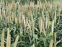
Remains of pearl millet, one of Africa’s oldest grain crops, are commonly found. Pearl millet is highly productive and resistant to adverse growing conditions, including drought. Cowpeas, valued for their high protein content, are also found at some sites. So far, pearl millet and cowpeas are the only crops known to have been cultivated by the Nok people. It is unclear whether they ate or farmed tubers of any kind. The numerous grinding stones found at Nok sites suggest that the grains were ground into flour and made into a type of porridge.
Pearl millet is commonly used to make bhakri flatbread. It is also boiled to make a Tamil porridge called kamban choru or “kamban koozh”. In Rajasthani cuisine, bajre ki khatti rabdi is a traditional Rajasthani dish made with pearl millet flour and yogurt. It is usually made in summers to be served along with meals.
https://en.m.wikipedia.org/wiki/Nok_culture
https://en.m.wikipedia.org/wiki/Pearl_millet
https://en.m.wikipedia.org/wiki/Agroforestry
There are over 1000 languages in West Africa.
https://www.bl.uk/west-africa/articles/language-script-and-symbol-in-west-africa
*
History of Africa – Ancient and Stateless Societies
Various kingdoms
READ MORE HERE:
https://www.cusd200.org/cms/lib/IL01001538/Centricity/Domain/267/_files/World_Civ_Chapter_15.pdf
A lineage, is a unilineal descent group whose members trace their descent from a common ancestor through an accepted sequence of known linking antecedents.
https://www.umanitoba.ca/faculties/arts/anthropology/tutor/descent/unilineal/lineages.html
*
West Africans were equally busy building up and toppling down their own kingdoms and empires. With wealth gained from vast herds of livestock, natural resources such as salt and gold, and control of trade routes, several states were able to conquer their less affluent and militarily-weaker neighbours to forge impressive empires.
https://www.worldhistory.org/collection/61/the-empires-of-west-africa/
*
The region south of the Sahara Desert was known as the Sahel, or sometimes the Western Sudan (this region is far to the west of the current countries of Sudan and Southern Sudan). This was mostly dry grassland, with some wetter areas, including two large rivers called the Senegal and the Niger. Plus there were several lakes in an area known as the Chad Basin.
Different communities built states, sometimes collaboratively, and sometimes forcefully. The earliest we know of was Wagadu, the state we usually call by the title of its ruler, Ghana. Headquartered near the Niger River, it was probably established around the end of the sixth century. Nearby, the city of Gao controlled a region that we know as Kawkaw. Further to the east, a number of communities combined to build the state of Kanem in the Chad Basin around the ninth century. Other states in this region soon followed, and it didn’t hurt that many shared the same language, called Hausa. To the west, the state of Takrur was built on the Senegal River around the ninth century. It was sometimes under the control of Wagadu, and sometimes independent.
These kingdoms competed and fought with each other, conducted diplomacy, formed alliances, and generally shared ideas about how to manage a kingdom. Despite their diversity and the vast size of this region, they had three major elements in common. We call these the Sahelian state model.
https://www.khanacademy.org/humanities/whp-origins/era-4-regional/42-systems-restructure-betaa/a/read-states-and-empires-of-west-africa-beta
*
Contact Admin:
Admin kan gekontak word by
volksvryheid9@gmail.com
*

[…] – IcebergsAncient kingdoms Western AfricaHendrik […]
LikeLike
[…] Ancient kingdoms Western Africa […]
LikeLike