*
The Treaty of Mudros ended Ottoman participation in World War I and effectively — if not legally—marked the dissolution of a once mighty empire. From its ruins, the victors of the First World War attempted to use the post-war peace negotiations to create a new, more unpredictable entity: the modern Middle East. It was signed by Rauf Bey, the Ottoman Minister of Marine, and the British Admiral Somerset Arthur Gough-Calthorpe, on board Agamemnon in Mudros harbor on the Aegean island of Lemnos.

*
As early as the first week of October 1918, both the Ottoman government and several individual Turkish leaders contacted the Allies to feel out peace possibilities. Britain, whose forces then occupied much of the Ottoman territories, was loath to step aside for its allies, particularly France, which according to an agreement concluded in 1916 would take control of the Syrian coast and much of modern-day Lebanon.
https://www.britannica.com/event/Armistice-of-Mudros
*
The Treaty of Mudros ended Ottoman participation in World War I and effectively—if not legally—marked the dissolution of a once mighty empire.
https://www.history.com/this-day-in-history/ottoman-empire-signs-treaty-with-allies
*
In 1917, in contradiction of Britain’s promise to the Arabs, the British Foreign Secretary Lord Balfour promised British Zionists that Great Britain would support the establishment of a Jewish homeland in Palestine, which was then a part of the Arab region ruled by the Ottoman Turks.
In 1916, in contradiction of promises both to the Zionists and the Arabs, Britain entered into the secret Sykes-Picot agreement with France.
It shows the areas that Great Britain and France agreed they would control after the Ottoman Empire was defeated and broken up. The area in purple includes much of what is now Israel/Palestine. See notes for the previous map regarding the three contradictory promises about this land that were made by Britain during the period of WWI.
https://www.history.com/this-day-in-history/britain-and-france-conclude-sykes-picot-agreement
https://www.jstor.org/stable/48505233?seq=1
At the same time, Britain agrees with France and Russia to carve up the Middle East into mutually agreed spheres of economic and political influence.
http://www.bu.edu/mzank/Jerusalem/p/period7-1-1.htm
*
PALESTINE
There are different maps …
The round pie-charts show the proportions of Arab and Jewish populations in all the regions of Palestine, the green sections of the circles being Arabs and the blue sections being Jewish. Altogether, the Jewish population comprised about one third of the Palestine’s population at this time. Comparing this to the previous map, clearly there were now a lot more Jewish residents in many more parts of Palestine than there had been 26 years earlier, in 1920. This was accomplished through large waves of immigration organized by the Zionist movement with the goal of establishing a state by and for Palestine’s Jewish inhabitants.

*
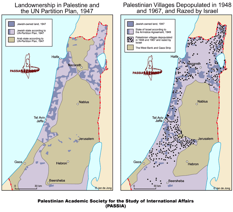
The map on the left shows the UN’s proposed Partition Plan of 1947: the blue area was to be a Jewish state (56% of Palestine) and the beige area an Arab state (44%).
The map on the right shows the borders that existed after the war of 1948-49 (called the “War of Independence” by Israelis, the “Nakba” (the “catastrophe”) by Palestinians. Both the blue and purple areas were controlled by Israel and the beige area is what remained under Arab control. Now 78% of Palestine was lost to the Arabs of Palestine. The West Bank (called that because it is land to the west of the Jordan River) and the Gaza strip – the two beige areas – comprise 22% of historic Palestine; that is all that remained for a possible Palestinian state.

These two maps also compare the borders of the proposed UN Partition Plan in 1947 and the 1949 Armistice borders. In both maps, the lighter lavender area is the area for Israel; the darker lavender areas within that are the locations of Jewish-owned land.
The map on the right shows many of the Arab Palestinian towns and villages that have been depopulated of Arabs and/or destroyed by Israel. The dots on a map this size cannot show the full range of destruction, which includes hundreds of Palestinian towns and villages.
All the Palestinian refugees from these communities, estimated to be about 750,000, had the inalienable right under international law to return to their homes after the fighting ceased. Israel committed a serious crime by destroying their homes and communities and not allowing the refugees to return to their land.
This intentional ethnic cleansing of Palestine is the Nabka, the catastrophe that befell the Palestinian people. It continues today with the illegal colonization and ethnic cleansing of the West Bank, under the Israeli military occupation that began in 1967.
*
DIE NAKBA IN PALESTINA
(VOLKSMOORDE)
Die Nakba in 1948 het gelei tot die verdryf van meer as 750 000 Palestyne uit hul vaderland. Nog etlike duisende is binne die nuutgeskepte staat Israel verplaas. Wat vandag gebeur, is die direkte gevolg van die Nakba en die rassistiese beleide inherent aan Sionistiese ideologie.
Die Deir Yassin-slagting van 9 April 1948 was nie die eerste slagting wat deur die Sioniste gepleeg is wat hul planne uitgevoer het om etnies te reinig en beheer oor die Heilige Land te neem nie. Maar die gebeurtenis is in die kollektiewe Palestynse bewussyn herdenk. Dit is die blywende simbool van die begin van die onteiening van die Palestynse volk. Ten tyde van die verdelingsplan het daar ongeveer 1,2 miljoen Arabiere en 608 000 Jode in Palestina gewoon, volgens die historikus Walid Khalidi.
Die verdeling het 54 persent van Palestina en die byna 500 000 Palestyne wat in daardie gebied woon aan die Jode gegee, van wie baie minder as 10 jaar in die gebied gewoon het, volgens Richard Curtiss, voormalige Amerikaanse diplomaat in die Midde-Ooste en ‘n mede- stigter van die Washington-verslag oor Midde-Ooste-aangeleenthede. Dit het nie net interne twis veroorsaak nie, maar baie Palestyne – selfs hele dorpies – was afgesny van hul groot bestaan: Landbou.
VERNIETIGING VAN LANDBOU, VOEDSELPRODUKSIE EN EKONOMIE
Verskillende areas word bome vernietig
‘n Bejaarde Plaasboer se bome word vernietig
*
Sedert 1967 het setlaars meer as 800 000 olyfbome in Palestynse besit ontwortel. Die verbranding van olyfbome en massale stukke landbougrond in die dorpie Burin, naby Nablus, in Julie staan uit as ‘n tragiese herinnering aan die voortdurende diefstal.
DIE NAKBA
Dit het nie in Oktober 2023 begin nie, maar hierdie beeldmateriaal, foto’s is reeds vanaf 1948 en daar is selfs voor dit begin om die burgers van Palestina totaal uit te wis. Nakba 2 is reeds sedert 1948 aan die gang om die midde ooste skoon te maak. Nog erger, Israel beweer daar is nie ‘n Palestina nie, alles word voor die voet vernietig en dan bou hulle bo-oor en maak alles van die verlede tot niet. Sionisme.
https://www.youtube.com/watch?v=H7FML0wzJ6A
&
NAKBA 2 IS REEDS SEDERT 1948 AAN DIE GANG, WERELDLEIERS KYK TOE DAT DIT GEBEUR EN SELFS SOMMIGE CHRISTENE PRAAT DIT GOED
https://www.youtube.com/watch?v=TMN2NqAPMpQ
NAKBA
The Nakba in 1948 resulted in the expulsion of more than 750,000 Palestinians from their homeland. Several thousand more were displaced within the newly created state of Israel. What’s happening today is the direct result of the Nakba and the racist policies inherent in Zionist ideology.
The Deir Yassin massacre of April 9, 1948, was not the first massacre perpetrated by the Zionists who were enacting their plans to ethnically cleanse and take control of the Holy Land. But the event has been memorialized in the collective Palestinian consciousness. It is the enduring symbol of the beginning of the dispossession of the Palestinian people.
That diaspora became a reality for Palestinians is not surprising considering the land became a mandate territory of Great Britain after the fall of the Ottoman Empire at the end of World War I. Under British rule, the number of Jewish settlers continued to grow as did the pressure to realize the Zionist plan of creating a Jewish homeland in Palestine. On Nov. 29, 1947, the United Nations General Assembly – under heavy pressure from the U.S. government – adopted Resolution 181, which effectively carved Palestine into two states; one Arab and one Jewish.
At the time of the partition plan, there were approximately 1.2 million Arabs and 608,000 Jews living in in Palestine, according to historian Walid Khalidi.
Partition gave 54 percent of Palestine and the nearly 500,000 Palestinians living in that area to the Jews, many of whom had been living in the area for less than 10 years, according to Richard Curtiss, former U.S. diplomat to the Middle East and a co-founder of the Washington Report on Middle East Affairs. Not only did it create internal strife, but many Palestinians – even whole villages – were cut off from their major livelihood: Agriculture.
Jaffa, the Palestinian state’s major Mediterranean Sea port was cut off from the country’s interior, and Gaza lost its connection to the wheat fields of the Negev, according to Khalidi, who is also a professor and co-founder of the Institute for Palestine Studies, and author of “All That Remains: The Palestinian Villages Occupied and Depopulated By Israel in 1948.” (Institute for Palestine Studies, 1992)
The Palestinian state also lost direct access to both the Red Sea and to Syria.
During the months leading up to the Nakba and until the armistice agreement was signed in January 1949, more than 750,000 Palestinians were forced from their homes and 13,000 Palestinians were killed. The Zionists eradicated more than 500 villages and towns, completely erasing some of them from the face of the earth.
“By the end of the war, hundreds of entire villages had not only been depopulated but obliterated, their houses blown up or bulldozed. While many of the sites are difficult to access, to this day the observant traveler of Israeli roads and highways can see traces of their presence that would escape the notice of the casual passerby: A fenced-in area – often surmounting a gentle hill – of olive and other fruit trees left untended, of cactus hedges and domesticated plants run wild. Now and then a few crumbled houses are left standing, a neglected mosque or church, collapsing walls along the ghost of a village lane, but in the vast majority of cases all that remains are a scattering of stones and rubble across a forgotten landscape.” Khalidi wrote in “All That Remains.”
Plan Dalet and the Transfer of Palestinians
The Zionist plans for transferring Palestinians out of their homeland was made clear in the Plan Dalet, the master defense plan of the army, the Haganah, dated March 10, 1948. The manifesto outlined how the Jewish conquest of Palestine should be carried out. A major portion of the plan outlined how Jewish fighters were to secure and take control of villages and areas outside the boundaries the United Nations had set for the state of Israel.
“Zionism’s responsibility for the Palestinian exodus and diaspora is an integral part of the genesis of the State of Israel,” Khalidi wrote in a 1961 article titled, “Plan Dalet: Master Plan for the Conquest of Palestine.”
READ MORE
https://www.ampalestine.org/palestine-101/history/al-nakba/nakba-what-really-happened
https://www.ampalestine.org/sites/default/files/attachment/2016/03/nakbabookwebformat.pdf
*
“‘Plan Dalet’ of ‘Plan D’ was die naam wat die Sionistiese Hoë Bevel gegee het aan die algemene plan vir militêre operasies binne die raamwerk waarvan die Sioniste opeenvolgende offensiewe in April en vroeg Mei 1948 in verskeie dele van Palestina van stapel gestuur het. Hierdie offensiewe, wat die vernietiging van die Palestyns-Arabiese gemeenskap en die uitsetting en verarming van die grootste deel van Palestynse Arabiere behels het, was bereken om die “militêre fait accompli” te bereik waarop die staat Israel gebaseer sou wees.”.
Alle gebiede van Palestina, hetsy Arabiere, Jode of Christene wat in die gebiede woonagtig is, word onwettig beset, veral snags word die meeste besettings uitgevoer. Dit is wat daaragter geskuil het, dit wat in die nag plaasvind. Vandag doen hulle die Gaza en Wesoewer helder oordag. HAMAS, wat deur Israel geskep is, is maar eers van 2007 in Gaza, terwyl al die besettings en bomaanvalle sedert 1920 reeds uitgevoer word. Lande wat Palestina of selfs Hamas (wat maar net in Gaza is), word ook gebom en menselewens verwoes. Vlugtelinge wat wel landuit kom, word elders gehuisves en daardie lande moet hulle versorg, soms en meestal is mediese sorg nodig en vlugtelinge vlug met ‘n paar besittings landuit.
Besettings deur Israel, die tipe van geweldadige optredes word deur heelwat christene goedgekeur. Dit wil sê , as Israel klaargespeel het met die bewoners van Palestina, sal hul hul dan vestig op hul volgende prooi en dieselfde uitvoer, want dit word dan alles goedgekeur deur meeste christene. Gelukkig is daar baie christene wat dit nie goedkeur nie.
Die burgers in SA kan nie eers die ANC, EFF of ander aanvat wat ons wil vermoor oor besettings en onteiening van bates en grond nie, want die “christen” mense keur dit dan goed dat Israel reg optree teenoor die in Palestina? Onwettige besettings is en bly onwettig. Ons in SA weet dit , dit is teen die internasionale reg, maar hoe kan van ons mense dit wat in Israel gebeur steun, en in SA is hulle daarteen gekant?
https://jewishvoiceforpeace.org/plan-daleth-plan-d-2/
*
*
“Transfer” in Zionist Thinking
- From the earliest days of modern political Zionism, its advocates grappled with the problem of creating a Jewish majority state in a part of the world where Palestinian Arabs were the overwhelming majority of the population. For many, the solution became known as “transfer,” a euphemism for ethnic cleansing.
- As far back as 1895, the father of modern political Zionism, Theodor Herzl, wrote: “We shall try to spirit the penniless population across the border by procuring employment for it in the transit countries, while denying it any employment in our own country… expropriation and the removal of the poor must be carried out discreetly and circumspectly.”
- By August 1937, “transfer” was a major subject of discussion at the Twentieth Zionist Congress in Zurich, Switzerland. Alluding to the systematic dispossession of Palestinian peasants (fellahin) that Zionist organizations had been engaged in for years, David Ben-Gurion, who would become Israel’s first prime minister in 1948, stated:
-
“You are no doubt aware of the [Jewish National Fund’s] activity in this respect. Now a transfer of a completely different scope will have to be carried out. In many parts of the country new settlement will not be possible without transferring the Arab fellahin.” He concluded: “Jewish power [in Palestine], which grows steadily, will also increase our possibilities to carry out this transfer on a large scale.”
- In June 1938, Ben-Gurion told a meeting of the Jewish Agency: “I support compulsory transfer. I don’t see anything immoral in it.”
- In December 1940, Joseph Weitz, director of the Jewish National Fund’s Lands Department, which was tasked with acquiring land for the Zionist enterprise in Palestine, wrote in his diary:
There is no way besides transferring the Arabs from here to the neighboring countries, and to transfer all of them, save perhaps for [the Arabs of] Bethlehem, Nazareth and Old Jerusalem. Not one village must be left, not one [bedouin] tribe. And only after this transfer will the country be able to absorb millions of our brothers and the Jewish problem will cease to exist. There is no other solution.
Details of Plan Dalet
- On March 10, 1948, Zionist political and military leaders, including Ben-Gurion, met in Tel Aviv and formally adopted Plan Dalet (or Plan D). The operational military orders specified which Palestinian population centers should be targeted and laid out in detail a blueprint for their forcible depopulation and destruction. It called for:
Mounting operations against enemy population centers located inside or near our defensive system in order to prevent them from being used as bases by an active armed force. These operations can be divided into the following categories:
Destruction of villages (setting fire to, blowing up, and planting mines in the debris), especially those population centers which are difficult to control continuously.
Mounting search and control operations according to the following guidelines: encirclement of the village and conducting a search inside it. In the event of resistance, the armed force must be destroyed and the population must be expelled outside the borders of the state.
- The Haganah (soon to be Israeli army) launched military operations under Plan Dalet at the beginning of April 1948. Although attacks by Zionist forces against Palestinian population centers actually began a few days after the UN Partition Plan was passed on November 29, 1947, with the adoption of Plan Dalet expulsions accelerated and became systematic, marking a new phase in the conflict in which Zionist and then Israeli forces went on “the offensive,” in the words of Israeli historian Benny Morris.
- Following Israel’s establishment on May 14, 1948, the new Israeli government set up an unofficial body, the “Transfer Committee,” to oversee the destruction of Palestinian towns and villages or their repopulation with Jews, and to prevent displaced Palestinians from returning to their homes. In a report presented to Ben-Gurion in June 1948, the three-man committee, which included the JNF’s Weitz, called for the “destruction of villages as much as possible during military operations.”
Results
- By the time the state of Israel was declared on May 14, 1948, more than 200 Palestinian villages had already been emptied as people fled in fear or were forcibly expelled by Zionist forces, and approximately 175,000 Palestinians had been made refugees. By 1949, at least 750,000 Palestinians had been made refugees, losing their land, homes and other belongings in what became known as the “Nakba” (“catastrophe”). Their flight was accelerated by massacres such as the one that took place on April 9, 1948, at Deir Yassin near Jerusalem, where approximately 100 Palestinian men, women, and children were murdered by Zionist paramilitaries. Today, refugees displaced during Israel’s creation and their descendants number approximately 7.1 million people.
- Some 400 Palestinian towns and villages, including vibrant urban centers, were systematically destroyed or taken over by Israeli Jews. Most of them were demolished to prevent the return of their Palestinian residents, now refugees outside of what would become Israel’s internationally recognized borders, or internally displaced inside of them.
- Only about 150,000 Palestinians remained inside what became Israel, many of them internally displaced people. Although they were granted Israeli citizenship, they were governed by Israeli military rule until 1966, had most of their land taken from them, and continue to suffer widespread, systematic discrimination today.
https://imeu.org/article/plan-dalet
*
NOVA CITY – ISRAEL – GAZA
Lebanese Researcher Rafic Nasrallah: The October 7 Nova Festival – Part Of A Zionist Plot To Build The Tokyo-Like ‘Nova City’ On The Ruins Of Gaza
Interviewer: “Where would that be?”
Nasrallah: “On the land of Gaza itself, after it would be pulverized. That’s what they think, but the great [Palestinian] people…”
Interviewer: “Is it connected to the Talmudic doctrine?”
Nasrallah: “Yes. ‘Nova’ is one of the projects that came with the founding of the [Zionist] entity.”

Lebanese researcher Rafic Nasrallah said on a December 15, 2023, show on Al-Manar TV (Hizbullah-Lebanon) that Israel plotted to destroy Gaza and establish a city on its ruins in 1948. He said that the city, which was intended to be called “Nova City,” was supposed to be the most important city in the region, “similar to Tokyo.” Nasrallah claimed that the Nova festival, which was held on October 7, and many of its participants were massacred, was named for this “Nova City,” and Israeli dreams to establish it.
Rafic Nasrallah: “The plot against Gaza is old. Historically speaking, there was a plan in 1948 called ‘Nova City.’ The plan was to build Nova City, which would be the most important city in the [Middle] East, and would be similar to Tokyo. That city was meant to be built after the destruction of Gaza. Now some people might know that the party that was held on October 7, where we saw the people running away and the Israeli helicopters shooting at them…What was the name of that party? Nova! It was called ‘Nova’ because some Israelis still dream of building that city. Some people even say that they are already selling plots for that project.”
NOVA CITY
the Business plan when Gaza has been destroyed
*
*
Contact Admin:
Admin kan gekontak word by
volksvryheid9@gmail.com

[…] Ottomans – Arabs – Palestine – Israel – England – France […]
LikeLike
[…] Doctrine AmericaOttomans – Arabs – Palestine – Israel – England – FranceKibbutz called Jan SmutsLand of KurdsKurdish – Syria – Turkey – Russian (violation of […]
LikeLike
[…] Jan Smuts en Brittanje (44) Ottomans – Arabs – Palestine -Israel – England – France […]
LikeLike
[…] Ottomans – Arabs – Palestine – Israel – England – France […]
LikeLike
[…] Ottomans – Arabs – Palestine – Israel – England – Fran… […]
LikeLike
[…] Ottomans – Arabs – Palestine – Israel – England – France […]
LikeLike
[…] Brittanje en Frankryk Ottomans – Arabs – Palestine – Israel – England – France […]
LikeLike
[…] artikels en inligtingOttomans – Arabs – Palestine – Israel – England – FranceBalfour verklaring – Jan SmutsJaffa Palestina 1900Jaffa 1900 […]
LikeLike
[…] Ottomans – Arabs – Palestine – Israel – England – France […]
LikeLike
[…] Ottomans – Arabs – Palestine – Israel – England – France […]
LikeLike
[…] Ottomans – Arabs – Palestine – Israel – England – France […]
LikeLike
[…] Drobles plan – Trump (2020)Ottomans – Arabs – Palestine – Israel – England – FranceBalfour verklaring – Jan SmutsJaffa 1900 (Ottomans) (Brittanje)J C Smuts, Balfour, […]
LikeLike
[…] Brittanje en Frankryk Ottomans – Arabs – Palestine – Israel – England – France […]
LikeLike
[…] Ottomans – Arabs – Palestine – Israel – England – France […]
LikeLike
[…] Brittanje en FrankrykOttomans – Arabs – Palestine – Israel – England – France […]
LikeLike
[…] Ottomans – Arabs – Palestine – Israel – England – France […]
LikeLike
[…] Ottomans – Arabs – Palestine – Israel – England – France […]
LikeLike
[…] Ottomans – Arabs – Palestine – Israel – England – France […]
LikeLike