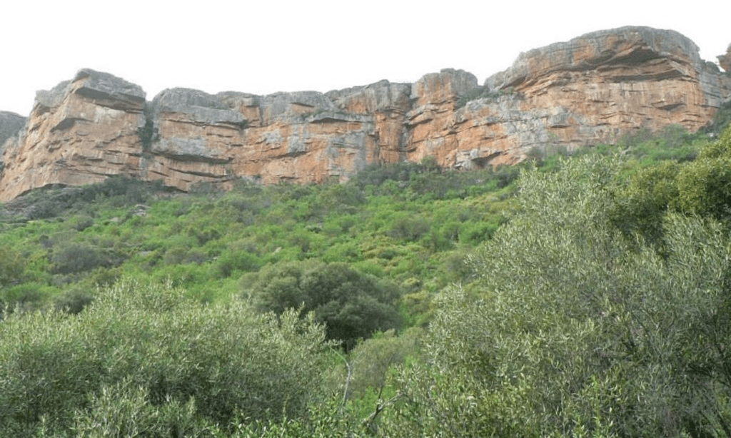
Oorlogskloof is the name of the farm where the glacial pavement is located. The name is Afrikaans and translates as “War Valley”. Oorlogskloof is located about 4 hours drive north of Cape Town, South Africa, near the town of Nieuwoudtville. The glacial pavement is about 300 m wide and 140 m long. On the pavement, you can see impressive glacial grooves that were carved by Dwyka glaciers 300 million years ago. A fence protects the site, which is a short distance off the road. A nice information sign has been put up, with explanation both in Afrikaans and English.

*
Die wonders van die wêreld is op ons drumpel, in die Noord-Kaap, alles om te geniet.
Oorlogskloof in die Noord-Kaap, die naam van die plaas waar daar miljoene jare gelede ‘n gletserspad ontwikkel het. Daar is ander gewilde plekke ook, foto’s getuig daarvan. Oorlogskloof is Afrikaans en vertaal as “War Valley”. Hierdie is maar een van baie sulke voorbeelde.
Die plaas is ongeveer 4 uur se ry noord van Kaapstad, naby Nieuwoudtville geleë. Op die oog af, is die gletserspad is ongeveer 300 m breed en 140 m lank. Op die sypaadjie word indrukwekkende gletsergroewe gesien wat 300 miljoen jaar gelede deur Dwyka -gletsers gesny is. Spore is dus ingekerf in rotse wat oeroud is.
Indrukwekkend, is daar ook ‘n heining wat die perseel beskerm. Dit is ‘n entjie van die pad af. Daar is ‘n mooi inligtingsbord aangebring, met verduideliking in Afrikaans sowel as in Engels. Maklik om te besoek.
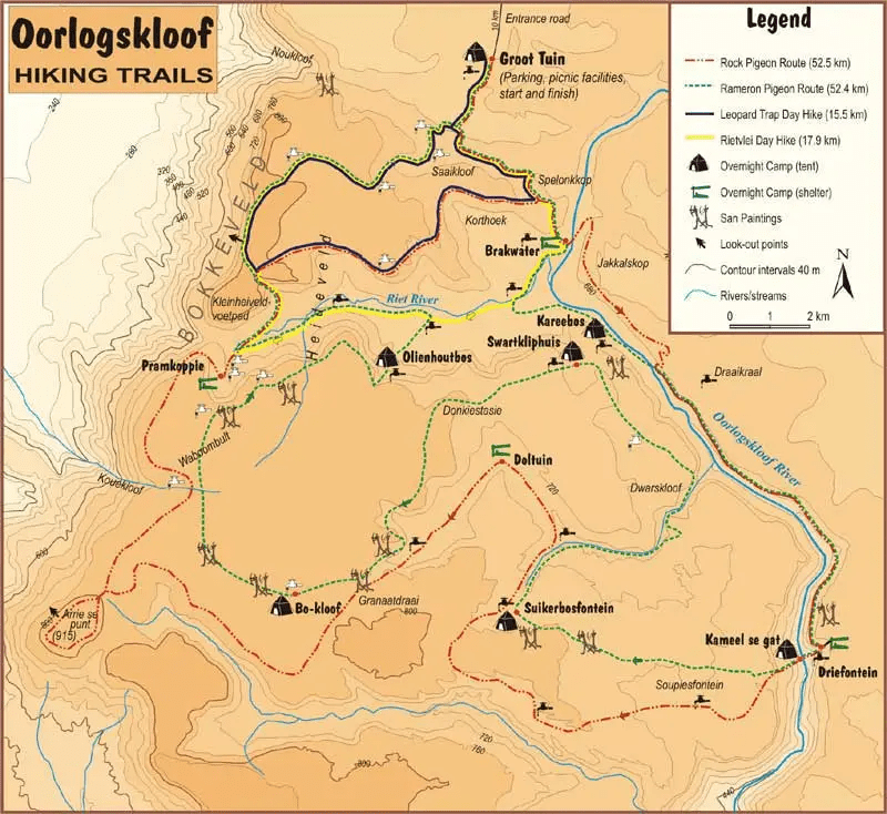
Oorlogskloof Nature Reserve
https://www.experiencenortherncape.com/visitor/experiences/oorlogskloof-nature-reserve-
https://afritrails.com/trail/oorlogskloof-rock-pigeon-trail-oorlogskloof-nature-reserve/2779
*
Elemente
Die elemente van die natuur is en was nog altyd groter as die mensdom self. Aards-elemente besit kragtige boodskappe aan elkeen van ons en het altyd ‘n verrassende manier om direk of indirek met ons te spreek. Meestal dodelik en gevaarlik, moederaarde besluit daaroor. Die aarde se boeg borrel soms na bo en laat spesifieke spore aan ons na om te geniet en bewonder. Koester elke oomblik van alles rondom en binne die elemente wat spesiaal vir ons geskep is.
Ysige rotsvoertuie is sterk, veral as dit moontlik gemeng is met fyner klippe en minerale of modderwater, in aantog wat oor alles hardloop? Die gerammel van klippe skuur teen mekaar in die water en neem ander saam hul tog. Dit hardloop soms in vuurtonge en laat ‘n swart spoor agter. Die gerammel weerklink soos naderende donderweer of dalk veel erger, herinner aan aardskeurings en aardbewings, Dit sleur alles mee in hul pad omdat rotse of klippe teen ‘n spoed voortbeurt. Jare gelede was daar grotes en kleineres.
Moontlik eens woongebiede van mense en diere, skuur rotse teen mekaar en vorm later ronde, gladde voorwerpe. Dit laat ‘n sleepselspoor agter. Sommige formasies getuig wat soms miljoene jare oud kan wees. Die moontlikheid bestaan dat die pad uitgekap uit rotse nooit enige bestemmings vir mense was nie, dalk ‘n oerwoud, groot bome wat versteen het.
*
Oorlogskloof 2019 42km Google Earth tour
https://www.youtube.com/watch?v=hvOPbgf1g_g
*
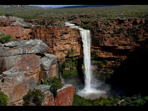
An overview of the Oorlogskloof Nature Reserve, its hiking trails and features. Visuals were taken at the Waterfall Canyon on the Papkuilsfontein guest farm. The waterfall is active only during the wet winter months. Produced courtesy of http://www.MountainPassesSouthAfrica.co.za
https://www.youtube.com/watch?v=nZatRnnGQe8
*
*
Oorlogskloof
https://www.youtube.com/watch?v=nZatRnnGQe8

[…] Oorlogskloof is located about 4 hours drive north of Cape Town. More about the Glacial Pavements. Glacial Pavements […]
LikeLike