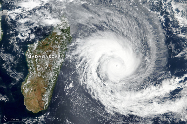
Just two weeks after being soaked by flooding rain from Tropical Storm Ana, citizens of Madagascar braced for the arrival of another potent cyclone. The Visible Infrared Imaging Radiometer Suite (VIIRS) on the NOAA-NASA Suomi NPP satellite acquired this natural-color image of Cyclone Batsirai on February 2, 2022.

*
Around the time this image was acquired, Batsirai had sustained winds of 235 kilometers (145 miles) per hour. Forecasts from the U.S. Joint Typhoon Warning Center suggest the cyclone is likely to make landfall in Madagascar late on February 4.
https://earthobservatory.nasa.gov/images/149418/cyclone-batsirai
*
Daar is reeds 3 stelsels in die kaart wat ons aandag vereis. Die een in die Wes-Kaap, die een uit Angola, Namibië en noorde en dan is dit die sikloon self. Die sikloon is groot, let op hoe wyd loop sy, haar agterstewe is beslis nie klein as daar na al die foto’s gekyk word nie. Sy is groter as Madagaskar en plaas dit op ‘n Weskus-kaart self. Daar is heelwat videos oor Batsirai. Indien sy wegbeweeg van ons kuslyn af, het ons wat voorsorg getref het, niks verloor daardeur nie.
In die Noordkus was daar in 1984 en 1987 groot stelsels en siklone wat ‘n groot invloed op ons almal gehad het. Brue was weggespoel en selfs in ‘n dorp of stad, was mense van hul huise afgesny.
Sorg dat geute en dreineringstelsels van erf of besighede skoon is, dit behoort altyd so te wees dat dit nie geblok is en jou as eienaar / besigheid direk raak nie. Tref eerder voorsorg asb. Indien die sikloon ons wel tref, het ons niks verloor deur genoegsame voorsorg te tref nie.
Niemand weet wat die rigting of sterkte van hierdie sikloon Batsirai is nie, veral as dit Madagaskar getref het nie. Dit kan weer sterker word. Moet nooit die krag van water, wind of vuur onderskat nie.
*
All KwaDukuza beaches have been closed with immediate effect, on the KZN North Coast, in anticipation of tropical cyclone Batsirai.
https://www.news24.com/witness/news/kzn/all-kwadukuza-beaches-closed-on-kzn-north-coast-20220203
*
He said they were, in association with several weather forecasting services, also observing the development of two other severe weather advisories which are, unfortunately, also forecast to affect our local weather patterns at more or less the same time as cyclone Batsirai.
He said a very large mass of rainfall stretching from Namibia all the way across the Northern Cape and into the Eastern Cape was fast approaching the KZN coastline, and a massive cold front, which is developing in the Atlantic Ocean and currently approaching the Western Cape, was also predicted to reach us early next week.
Well done – The KZNSB operations management team in conjunction with the executive, have taken a decision to start removing all of the board’s shark safety gear from the water when boats launch this morning, February 3. This action is taken to prevent unnecessary losses and/or damage to equipment as a result of strong winds and heavy seas associated with these severe weather systems, and bathing will be closed at all recognised KZN bathing beaches as from February 4,” Thompson said.
*
Around the time this image was acquired, Batsirai had sustained winds of 235 kilometers (145 miles) per hour. Forecasts from the U.S. Joint Typhoon Warning Center suggest the cyclone is likely to make landfall in Madagascar late on February 4.
https://earthobservatory.nasa.gov/images/149418/cyclone-batsirai
*
*
Batsirai cyclone footage from Mauritius, destruction on videos, February 2, 2022
*
*
The island was placed on hurricane red alert Wednesday at 7 p.m. local time (10 a.m. Eastern Time), requiring residents to barricade themselves.
“Raise the red alert does not mean a return to normal. The consequences of the passage of the cyclone will still present dangers for the population. The emergency and intervention services will have to clear the roads, secure the electric wires, clear the accesses, restore the electricity, telephone and drinking water supply networks. Caution will therefore remain in order and travel is strongly discouraged”, “except in cases of force majeure”, assured Mr. Billant
“While the cyclone Help is just beginning to move away from Reunion, we are currently experiencing the worst weather conditions since the start of the episode,” said Emmanuel Cloppet, regional director of Météo-France, during a press briefing at the start of evening, local time. He thus evokes strong winds going “up to 150 km / hour in the heights”, the non-coastal areas of the island, and already more than 500 millimeters of rain recorded in the circuses (Reunion has three) and 1200 mm in the volcano massif.
“The deterioration will continue in the evening. The red alert therefore remains in full force tonight” and “everyone must remain confined”, added the prefect of the island Jacques Billant, who does not plan to lift the red alert until Friday at 9 a.m.

Dis goed as munisipaliteite voorbereidings tref indien Batsirai wel in ons rigting kom. NIEMAND WEET WAT DIE SIKLOON GAAN DOEN NIE.
*
