*
Die gesogte berg, Tafelberg beskik oor sy eie natuurlike windturbines as dit so genoem kan word. Turbines en wind energie wat vog inwaai oor die gebied en verder die binneland ingevoer word deur haar masjestieuse kragtige netwerke in die lug. Hierdie winde veroorsaak ‘n daaglikse verandering wat in die lug plaasvind. Die bure, Leeukop en Seinheuwel langsaan, asook die hele skiereiland speel ‘n groot rol om die spesifieke wolkformasies te vorm. Dit hou vir stappers ‘n groot gevaar in en dien as waarskuwing om eerder onder te bly as in die malende windspele. Soms speel dit ‘n groter invloed in die binneland as die swart suidoos waai, verwelkom deur Boere en landgenote. Hierdie berg soos ander, vorm groot deel van die weerpatrone in Suid-Afrika.

*
‘n Interessante artikel met foto’s wat op 16 Januarie 2011 deur Brian Higgins geplaas is, verduidelik hoe Orografiese wolkformasies rondom Tafelberg gevorm word.
Orographic Cloud Formation on Table Mountain, Cape Town – The word “orographic”, derived from Greek, is the field of knowledge about the formation and relief of mountains. Thus orographic cloud formation is how clouds form due to mountain reliefs. Table Mountain’s much photographed “table cloth” is an example of orographic cloud formation. When seen from afar it is strikingly beautiful, but up close it can be very dangerous to unwary hikers: cloud formation can rapidly engulf hikers and obscure their visibility.
Normally the “table cloth” forms during the summer months as a result of the south easterly winds (known as the Cape doctor). But as the the photos show, we are able to witness a mini “table cloth” formation along the west slopes of Table Mountain during a sunny day in July.
*
On 16 January 2011 the following article was published regarding Table mountain and its clouds, with nice photos:
Table Mountain with its flattened peak is Cape Town’s most recognized landmark. It can be seen nearly 100 miles out to sea. It was a beacon of safety for early seafarers who came to the Cape. It was a symbol of hope for those imprisoned on Robben Island during the turbulent apartheid years. Yet even when seen from afar, you cannot ignore the enormity of this iconic granite mass on its surroundings.
Table Mountain is flanked by two detached peaks: Lion’s Head to the northwest, and Devil’s Peak to the northeast. Lion’s Head declines to the north to merge into Signal Hill, forming the “lion’s rump”. The natural amphitheater-shaped area of Cape Town bordered by these four mountains is called the “City Bowl”.
An aerial perspective of Table Mountain and its subsidiary peaks is given by the following contour map (courtesy of the Table Mountain National Park). Also shown on the map are the numerous hiking trails for those adventurous hikers who wish to access popular land marks on the mountain peninsula.

You simply cannot visit Cape Town without making the pilgrimage to the top. For most visitors the trip to the top of the mountain starts with a breathtaking ride in the Table Mountain Arial Cable Car. During the ascent you get the first of many panoramic views of the city, and a close-up look at the granite face wall of the mountain. On route, the floor of the arial car continually rotates through 360 degrees, so everyone on board gets a chance to see and photograph different view points. The mountain is about 3560 ft above see level, and during the last 200 ft the car ascends almost parallel to the face wall: the view looking down is awesome, a tinge of nervousness and/or vertigo, notwithstanding. The trip takes less than 10 mins.
Shown below is a view of Lion’s Head from the top of Table Mountain. The peak is at 2,195 ft. Can you make out the “head of the lion”? Actually, if you have an aerial view that includes both Lion’s Head and Signal Hill, then taken together these two landmarks resemble a crouching lion (or sometimes related to a Sphinx.
*
This is why Signal Hill was originally known as Leeuwen Staart (Dutch for Lion’s Tail) by the Dutch settlers in the 17th century.
Kaapstad – Cape Town
Tafelberg en Leeukop
https://www.youtube.com/watch?v=4MFXQ-c6CYg

*
Lions Head
https://www.youtube.com/watch?v=qe8MFRTTjwI
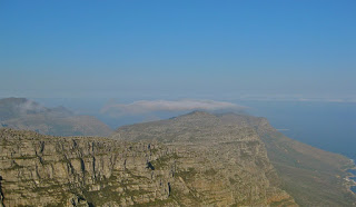
In the first photo we have the formation of a small cloud over a peak overlooking the sea-side resort of Llandudno.
*
After about 15 minutes we see the early stages of the “table cloth”. This is a nice example of lenticular clouds.
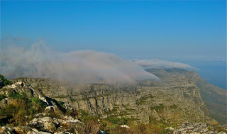
The “cloth” continues to grow quite rapidly (about 5 mins later)
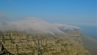
Starts to thicken
*
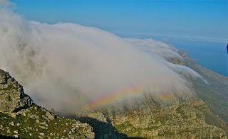
We were blessed with a rainbow. Note also how the clouds roll over the edge and then disappear: in this case the clouds encounter warmer air relative to the dew point, and thus the relative humidity decreases, reversing the process.
Shortly after this photo was taken, the Cable Car siren went off announcing that the Cable Car will be closing because or impending bad weather and every one was advised to leave the mountain post haste, which we did. When it comes to weather, Table mountain is very moody and unpredictable!
More photos: Beautiful.
Posted on 16 January 2011 by brian higgins
http://ekayasolutions.blogspot.com/2011/01/orographic-cloud-formation-on-table.html
*
#onafhanklik robben eiland
*
Contact Admin:
Admin kan gekontak word by
volksvryheid9@gmail.com
*

[…] Tafelberg/Table mountain […]
LikeLike
[…] Tafelberg/Table mountain […]
LikeLike
[…] https://www.cape-town-heritage.co.za/heritage-site/robben-island.html Tafelberg se natuurlike windturbines […]
LikeLike
[…] Tafelberg se natuurlike windturbines […]
LikeLike
[…] Tafelberg se natuurlike windturbines […]
LikeLike
[…] Tafelberg se natuurlike windturbines […]
LikeLike